Thundorf, Thurgau
| Thundorf | ||
|---|---|---|
 |
||
|
||
| Coordinates: 47°33′N 8°58′E / 47.550°N 8.967°ECoordinates: 47°33′N 8°58′E / 47.550°N 8.967°E | ||
| Country | Switzerland | |
| Canton | Thurgau | |
| District | Frauenfeld | |
| Government | ||
| • Mayor | Stefan Blatter | |
| Area | ||
| • Total | 15.61 km2 (6.03 sq mi) | |
| Elevation | 546 m (1,791 ft) | |
| Population (Dec 2015) | ||
| • Total | 1,424 | |
| • Density | 91/km2 (240/sq mi) | |
| Postal code | 8512 | |
| SFOS number | 4611 | |
| Localities | Thundorf, Kirchberg, Lustdorf, Wetzikon | |
| Surrounded by | Affeltrangen, Amlikon-Bissegg, Felben-Wellhausen, Frauenfeld, Hüttlingen, Lommis, Matzingen, Stettfurt | |
| Website |
www SFSO statistics |
|
Thundorf (pronounced [ˈtuːndɔrf], in the local dialect [ˈtuəndɔrfː] or [ˈtuəndərəfː]) is a municipality in the district of district of Frauenfeld in the canton of Thurgau in Switzerland.
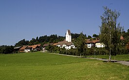
The village of Thundorf lies on a plateau above Frauenfeld. In 1995, the communal territory was enlarged to the east, when Wetzikon and Lustdorf, the latter of which until then was autonomous, were joined to it.
Blazon: Gules, a fess argent between three mullets of six points argent (2, 1).
The earliest mention of Thundorf dates back to the year 888 (Tuomsdorof/*tuomesdorf). This place name is composed by the OHG anthroponym Duomo/*Tuomo and the noun substantive dorf ‚hamlet, farm, village, estate, quarter of a town‘.
The village is mainly residential and has a large school with over 500 pupils. Despite having a population of over a thousand, Thundorf only has a single shop named "Volg" on the main street which serves the local population selling groceries and farming supplies. Transport to the village is provided by a daily bus service that operates between Frauenfeld and Weinfeld. The town is famous locally for its annual "Banae Tanz" festival which has been celebrated since shortly after the 1798 French Invasion and establishment of the helvetischen Republic of Loskauf and is held annually on September 9.
Thundorf has an area, as of 2009[update], of 15.61 square kilometers (6.03 sq mi). Of this area, 8.91 km2 (3.44 sq mi) or 57.1% is used for agricultural purposes, while 5.82 km2 (2.25 sq mi) or 37.3% is forested. Of the rest of the land, 0.88 km2 (0.34 sq mi) or 5.6% is settled (buildings or roads), 0.02 km2 (4.9 acres) or 0.1% is either rivers or lakes and 0.01 km2 (2.5 acres) or 0.1% is unproductive land.
...
Wikipedia


