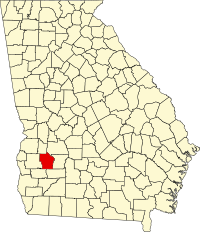
Terrell County, Georgia
| Terrell County, Georgia | |
|---|---|

Terrell County Courthouse in Dawson
|
|
 Location in the U.S. state of Georgia |
|
 Georgia's location in the U.S. |
|
| Founded | February 16, 1856 |
| Named for | William Terrell |
| Seat | Dawson |
| Largest city | Dawson |
| Area | |
| • Total | 338 sq mi (875 km2) |
| • Land | 335 sq mi (868 km2) |
| • Water | 2.3 sq mi (6 km2), 0.7% |
| Population | |
| • (2010) | 9,315 |
| • Density | 28/sq mi (11/km²) |
| Congressional district | 2nd |
| Time zone | Eastern: UTC-5/-4 |
| Website | www |
Terrell County is a county located in the southwestern portion of the U.S. state of Georgia. As of the 2010 census, the population was 9,315. The county seat is Dawson.
Terrell County is included in the Albany, GA Metropolitan Statistical Area.
Formed from portions of Randolph and Lee counties on February 16, 1856, by an act of the Georgia General Assembly, Terrell County is named for Dr. William Terrell (1778–1855) of Sparta, Georgia, who served in the Georgia General Assembly and the United States House of Representatives.
During the American Civil War, after Atlanta's capture by Union forces, a refugee settlement was established in Terrell County for civilians forced to flee the city. The Fosterville settlement, named after Georgia Quartermaster General Ira Roe Foster, was according to author Mary Elizabeth Massey in her 2001 history, the "most ambitious refugee project approved by the Georgia General Assembly" [during that period]. On March 11, 1865, the Georgia General Assembly authorized General Foster to "continue to provide for maintenance of said exiles, or such of them as are unable by their labor to support themselves, or their families for the balance of the present year."
...
Wikipedia
