Lee County, Georgia
| Lee County, Georgia | |
|---|---|

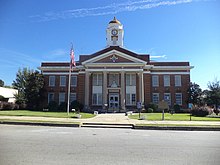
Lee County courthouse in Leesburg
|
|
 Location in the U.S. state of Georgia |
|
 Georgia's location in the U.S. |
|
| Founded | June 9, 1825 |
| Named for | Henry Lee III |
| Seat | Leesburg |
| Largest city | Leesburg |
| Area | |
| • Total | 362 sq mi (938 km2) |
| • Land | 356 sq mi (922 km2) |
| • Water | 5.9 sq mi (15 km2), 1.6% |
| Population | |
| • (2010) | 28,298 |
| • Density | 80/sq mi (31/km²) |
| Congressional district | 2nd |
| Time zone | Eastern: UTC-5/-4 |
| Website | www |
Lee County is a county located in the U.S. state of Georgia. As of the 2010 census, the population was 28,298. Its county seat is Leesburg.
Lee County is included in the Albany, GA Metropolitan Statistical Area.
The land for Lee, Muscogee, Troup, Coweta, and Carroll counties was ceded by the Creek people in the 1825 Treaty of Indian Springs. The counties' boundaries were created by the Georgia General Assembly on June 9, but they were not named until December 14, 1826. The county was named in honor of Henry Lee III.
According to the U.S. Census Bureau, the county has a total area of 362 square miles (940 km2), of which 356 square miles (920 km2) is land and 5.9 square miles (15 km2) (1.6%) is water.
Most of the western three-quarters of Lee County is located in the Kinchafoonee-Muckalee sub-basin of the ACF River Basin (Apalachicola-Chattahoochee-Flint River Basin). The eastern quarter of the county is located in the Middle Flint River sub-basin of the same ACF River Basin, while a very small corner in the south of Lee County is located in the Lower Flint River sub-basin of the same larger ACF River Basin. An even smaller southwestern corner is located in the Ichawaynochaway Creek sub-basin of the ACF River Basin.
...
Wikipedia
