Temescal Creek (Northern California)
| Temescal Creek | |
| Creek | |
|
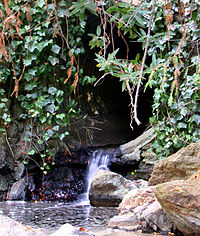
Temescal Creek as it comes aboveground at Temescal Regional Park
|
|
| Country | |
|---|---|
| State | California |
| Counties | Alameda County |
| City | Oakland |
| Source | |
| - location | Montclair District, Alameda County, California |
| - coordinates | 37°50′34″N 122°12′09″W / 37.84278°N 122.20250°W |
| Secondary source | Claremont Creek |
| - location | near Grizzly Park Boulevard |
| - coordinates | 37°52′08″N 122°13′01″W / 37.86889°N 122.21694°W |
| Mouth | culvert toward San Francisco Bay |
| - location | Oakland, Alameda County, California |
| - coordinates | 37°50′2″N 122°17′42″W / 37.83389°N 122.29500°WCoordinates: 37°50′2″N 122°17′42″W / 37.83389°N 122.29500°W |
Temescal Creek is one of the principal watercourses in the city of Oakland, California, United States.
The word "temescal" derives from the word temescalli, which means "sweat house" in the Nahuatl language of the Mexica ("Aztec") people of Mexico. The name was given to the creek when it became part of the Peralta's Rancho San Antonio. It is surmised that the Peraltas or perhaps one of their ranch hands (vaqueros) had seen local indigenous (Ohlone) structures along the creek similar to those in other parts of New Spain which were called temescalli.
Two forks begin in the Berkeley Hills in the northeastern section of Oakland (also referred to as the Oakland Hills), part of the Pacific Coast Ranges, coming together in the Temescal district of Oakland, then flowing westerly across Oakland and Emeryville to San Francisco Bay.
The north fork of Temescal Creek was renamed "Harwood's Creek" in the 19th century after the owner of land in the upper stretches of the north fork. It was renamed yet again "Claremont Creek" in the early 20th century after a residential development in the same vicinity, today's Claremont district.
The south fork begins in the northern section of Oakland's Montclair district, flowing southwest out of a canyon in the hills, then turning abruptly northwestward in the linear valley formed by the Hayward Fault. It then flows into Lake Temescal, a natural sag pond which was dammed in the 19th century to increase its capacity for use as a reservoir. Lake Temescal is now a public park.
...
Wikipedia

