Tate's Cairn
| Tate's Cairn | |||||||||||||||||||

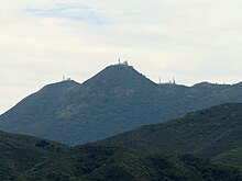
Tate's Cairn, viewed from the north. Tate's Cairn Meteorological Station is at the centre.
|
|||||||||||||||||||
| Chinese | 大老山 | ||||||||||||||||||
|---|---|---|---|---|---|---|---|---|---|---|---|---|---|---|---|---|---|---|---|
|
|||||||||||||||||||
| Transcriptions | |
|---|---|
| Standard Mandarin | |
| Hanyu Pinyin | Dà lǎo shān |
| Wade–Giles | Ta lao shan |
| IPA | [tâ làu ʂán] |
| Yue: Cantonese | |
| Yale Romanization | Tāi Lǒ Shàn |
| IPA | [tàːi.lɔ̬ː.sâːn] |
| Jyutping | Daai6 lou5 saan1 |
Tate's Cairn (Chinese: 大老山; Sidney Lau: Daai6 Lo5 Saan1, lit. Big Old Mountain) is a mountain peak in Hong Kong, 583 metres (1,913 ft) in height. It is one of the peaks of the Kowloon Ridge and falls within Ma On Shan Country Park.
Built in 1991 at a cost of HK$2 billion, Tate's Cairn Tunnel is a 3.9 kilometres (2.4 mi)-long twin-tube vehicular tunnel running north-south beneath the peak.
The Stage 4 to 5 transition of the MacLehose Trail is located beneath the cairn.
Coordinates: 22°21′29″N 114°13′04″E / 22.357994°N 114.217735°E
...
Wikipedia
