Tarasp
| Tarasp | ||
|---|---|---|
| Former municipality of Switzerland | ||

Lake Tarasp at dawn
|
||
|
||
| Coordinates: 46°46′N 10°15′E / 46.767°N 10.250°ECoordinates: 46°46′N 10°15′E / 46.767°N 10.250°E | ||
| Country | Switzerland | |
| Canton | Graubünden | |
| District | Inn | |
| Area | ||
| • Total | 46.9 km2 (18.1 sq mi) | |
| Elevation | 1,403 m (4,603 ft) | |
| Population (Dec 2014) | ||
| • Total | 337 | |
| • Density | 7.2/km2 (19/sq mi) | |
| Postal code | 7553 | |
| SFOS number | 3745 | |
| Localities | Fontana, Vulpera, Sparsels, Aschera, Avrona, Chaposch, Chants, Florins, Nairs, Sgnè, Vallatscha | |
| Surrounded by | Ardez, Ftan, Scuol, Tschierv, Zernez | |
| Website |
www SFSO statistics |
|
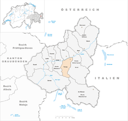
Tarasp is a former municipality in the district of Inn in the Swiss canton of Graubünden. Its eleven settlements are situated within the Lower Engadin valley along the Inn River, at the foot of the Sesvenna Range. On 1 January 2015 the former municipalities of Ardez, Guarda, Tarasp, Ftan and Sent merged into the municipality of Scuol.
Originally a Romansh language area, the majority of the population today speaks High Alemannic German. Unlike the surrounding municipalities, the Tarasp parish is mainly Catholic.
Primitive grinding stones known as or Hexensteine were found in the Tarasp area. This indicates that stone age food processing happened in the area. However, there are no records or indications of settlements in the area until the 11th Century.
The Lordship of Tarasp Castle was established in the 11th century and for centuries claimed by the Bishopric of Chur and the Counts of Tyrol. After the Lords of Tarasp had become extinct, their estates were a Tyrolean fief from 1239 on. Under the rule of the Habsburg archdukes of Austria, also Counts of Tyrol since 1363, Tarasp from 1464 on was an Austrian exclave inside the Free State of the Three Leagues, an associate of the Old Swiss Confederacy. In 1687 Emperor Leopold I of Habsburg granted the Lordship of Tarasp to the Princes of Dietrichstein as an immediate territory of the Holy Roman Empire.
...
Wikipedia


