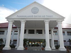
Tanay, Rizal
| Tanay | |||
|---|---|---|---|
| Municipality | |||

Tanay Municipal Hall
|
|||
|
|||
| Nickname(s): Tourism Capital of Rizal/Home of Summer Resort of the Philippines | |||
 Map of Rizal showing the location of Tanay |
|||
| Location within the Philippines | |||
| Coordinates: 14°29′50″N 121°17′11″E / 14.49722°N 121.28639°ECoordinates: 14°29′50″N 121°17′11″E / 14.49722°N 121.28639°E | |||
| Country | Philippines | ||
| Region | CALABARZON (Region IV-A) | ||
| Province | Rizal | ||
| District | 2nd District of Rizal | ||
| Founded | 1606 | ||
| Barangays | 20 | ||
| Government | |||
| • Mayor | Rex Manuel C. Tanjuatco | ||
| Area | |||
| • Total | 200.00 km2 (77.22 sq mi) | ||
| Population (2015 census) | |||
| • Total | 117,830 | ||
| • Density | 590/km2 (1,500/sq mi) | ||
| Time zone | PST (UTC+8) | ||
| ZIP code | 1980 | ||
| IDD : area code | +63 (0)2 | ||
| Income class | 1st | ||
| Website | www |
||
Tanay is a first class municipality in the province of Rizal, Philippines. According to the 2015 census, it has a population of 117,830 people.
It is located 57 kilometres (35 mi) east of Manila, although a typical commute between Manila and Tanay will take between one and three hours depending upon traffic conditions. It contains portions of the Sierra Madre Mountains and is bordered by Antipolo City in the north-west, Baras, Morong and Teresa in the west, General Nakar (Quezon Province) in the east, and Pililla, Santa Maria (Laguna province) as well as the lake Laguna de Bay in the south.
Tanay was settled by early Austronesian people. Shortly after the conquest and subjugation of Manila by the Spaniards and the surrounding lake areas by Juan de Salcedo in 1570-1574, Franciscan missionaries arrived to Christianize the inhabitants of what is now the Morong-Pililla area. In 1583, both Morong and Pililla were created as separate towns with Tanay forming part of Pililla.
Tanay was founded as a separate pueblo (town) in 1606 under the name "Monte de Tan-ay". In 1620, administration was moved to San Antonio (now called Inalsan or Pantay) and Tandang Kutyo. In 1638, the town was burned during an uprising of Chinese living in the area, and the town was rebuilt in 1640 at the present day location.
In 1747, the town of Tanay consisted of only eight barangays, namely Nuestra Senora del Rosario, Sa Josep, San Ildefonso de Tanay, San Francisco de Maytubig, San Pedro de Alcantara, San Lucas y San Antonio, San Apostol and San Agustin de Balugbog.
...
Wikipedia


