Tagbilaran, Bohol
| Tagbilaran | |||
|---|---|---|---|
| Component City | |||

Tagbilaran, Bohol
|
|||
|
|||
| Nickname(s): City of Peace and Friendship | |||
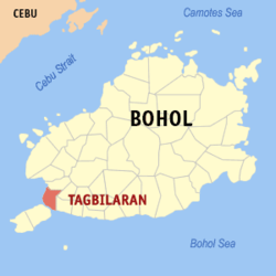
 Map of Bohol with Tagbilaran highlighted |
|||
 Map of Tagbilaran showing barangays and islands |
|||
| Location within the Philippines | |||
| Coordinates: 9°39′N 123°51′E / 9.65°N 123.85°ECoordinates: 9°39′N 123°51′E / 9.65°N 123.85°E | |||
| Country | Philippines | ||
| Region | Central Visayas (Region VII) | ||
| Province | Bohol (capital) | ||
| District | 1st district of Bohol | ||
| Incorporated • Town • City |
9 February 1742 1 July 1966 |
||
| Barangays |
15 (see § Barangays)
|
||
| Government | |||
| • Type | Sangguniang Panlungsod | ||
| • Mayor | John Yap (LP) | ||
| • Vice mayor | Jose Veloso | ||
| • City Council |
Members
|
||
| • Representative | Rene Relampagos | ||
| Area | |||
| • Total | 36.50 km2 (14.09 sq mi) | ||
| • Land | 32.70 km2 (12.63 sq mi) | ||
| Population (2015 census) | |||
| • Total | 105,051 | ||
| • Density | 2,900/km2 (7,500/sq mi) | ||
| • Voter (2016) | 59,949 | ||
| Demonym(s) | Tagbilaranon | ||
| Time zone | PST (UTC+8) | ||
| Zip code | 6300 | ||
| IDD : area code | +63 (0)38 | ||
| Income class | 3rd class | ||
| PSGC | 071242000 | ||
| Website | tagbilaran |
||
| Flag |
|
|---|---|
| Hymn | Tagbilaran Hymn |
| Dance | Kuradang |
| Bird | Tailor bird (Tamsi) |
| Fish | Rabbitfish (Danggit) |
| Flower | Bougainvillea |
| Tree | Acacia |
| Plant | Golden Duranta |
Tagbilaran is a city in the Visayas group of islands in the Philippines. It is the seat and component city of the island province of Bohol with a population of 105,051 as of 2015 census. In the 2016 electoral roll, it had 59,949 registered voters.. Encompassing a land area of 32.7 km2 (12.6 sq mi), with a coastline of 13 km (8.1 mi) on the southwestern part of the island, the city shares its boundaries with the towns of Cortes, Corella, and Baclayon.
Tagbilaran is the principal gateway to Bohol, 630 km (390 mi) southeast of the national capital of Manila and 72 km (45 mi) south of the regional capital, Cebu City.
A hundred years before Spaniards arrived in the Philippines, the settlement which eventually became Tagbilaran was already involved in trading with China and Malaya. This early settlement had contact with the Spaniards in 1565, when the Spanish conquistador Miguel López de Legazpi and the native chieftain Datu Sikatuna pledged peace and cooperation through the famous blood compact.
(San Jose de) Tagbilaran was established as a town on 9 February 1742, by General Don Francisco Antonio Calderón de la Barca, Governor of the Visayas, who separated it from the town of Baclayon. The town was dedicated to St. Joseph the Worker. Since then it was part of the province of Bohol until it became a chartered city on 1 July 1966, by virtue of Republic Act No. 4660.
The city was occupied by the United States during the Philippine-American War and by Imperial Japan during World War II.
Sitio Ubos (Lower Town) is Tagbilaran's former harbor site and is considered to be the city's oldest portion, having been a busy trading center since the seventeenth century until the early twentieth century. As such, the place houses the oldest and largest number of heritage houses in Bohol. Sitio Ubos declined as a major port towards the end of the Spanish era when the causeway to Panglao Island was constructed. Since then, the area lost its former glory and its old houses were either demolished or neglected.
...
Wikipedia


