Central Visayas
|
Central Visayas Region VII |
|||||
|---|---|---|---|---|---|
| Region | |||||
|
|||||
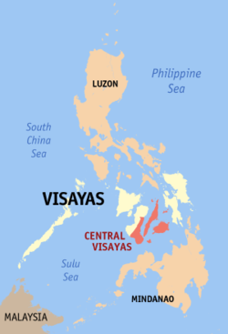
 Location in the Philippines |
|||||
| Coordinates: 10°00′N 123°30′E / 10°N 123.5°ECoordinates: 10°00′N 123°30′E / 10°N 123.5°E | |||||
| Country | Philippines | ||||
| Island group | Visayas | ||||
| Regional center | Cebu City | ||||
| Area | |||||
| • Total | 10,500.44 km2 (4,054.24 sq mi) | ||||
| Population (2015 census) | |||||
| • Total | 6,041,903 | ||||
| • Density | 580/km2 (1,500/sq mi) | ||||
| Time zone | PST (UTC+8) | ||||
| ISO 3166 code | PH-07 | ||||
| Provinces | 3 | ||||
| Cities | 10 | ||||
| Municipalities | 97 | ||||
| Barangays | 2,446 | ||||
| Cong. districts | 14 | ||||
| Languages | |||||
Central Visayas (Filipino: Gitnang Kabisayaan; Cebuano: Tunga-tungang Kabisay-an) is a region of the Philippines, designated as Region VII. It is located in the central part of the Visayas island group, and consisists of three provinces: Bohol, Cebu and Siquijor; and three highly urbanized cities: Cebu City, Lapu-Lapu, and Mandaue. Cebu City is the regional center. The region is dominated by the native speakers of Cebuano. The land area of the region is 10,102 square kilometres (3,900 sq mi), with a population of 6,041,903 people.
On May 29, 2015, the region was redefined, when Region VII lost the province of Negros Oriental to the newly formed Negros Island Region.
Regions first came to existence in on September 24, 1972, when the provinces of the Philippines were organized into 11 regions by Presidential Decree No. 1 as part of the Integrated Reorganization Plan of President Ferdinand Marcos.
By virtue of Executive Order No. 183 issued on May 29, 2015 by President Benigno Aquino III, the province of Negros Oriental was transferred to the Negros Island Region.
In the 2013 electoral roll, it had 4,114,046 registered voters, meaning that 68% of the population are aged 18 and over.
...
Wikipedia


