Szepes (county)
| Szepes County Comitatus Scepusiensis (Latin) Szepes vármegye (Hungarian) Komitat Zips (German) Spišská župa (Slovak) |
|||||
| County of the Kingdom of Hungary | |||||
|
|||||
|
Coat of arms |
|||||
| Capital |
Lőcse 49°1′N 20°35′E / 49.017°N 20.583°ECoordinates: 49°1′N 20°35′E / 49.017°N 20.583°E |
||||
| History | |||||
| • | Established | 11th century | |||
| • | Treaty of Trianon | 4 June 1920 | |||
| Area | |||||
| • | 1910 | 3,654 km2(1,411 sq mi) | |||
| Population | |||||
| • | 1910 | 172,900 | |||
| Density | 47.3 /km2 (122.6 /sq mi) | ||||
| Today part of | Slovakia, Poland | ||||
| Levoča is the current name of the capital. | |||||
Coat of arms
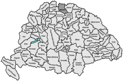
Szepes (Slovak: Spiš; Latin: Scepusium, Polish: Spisz, German: Zips) was an administrative county of the Kingdom of Hungary, called Scepusium before the late 19th century. It's territory today lies in northeastern Slovakia, with a very small area in southeastern Poland. For the current region, see Spiš.
Szepes county shared borders with Poland and with the counties as follows: Liptó, Gömör, Abaúj and Sáros. After the late 18th century dismemberment of Poland, the border was with the Austrian province of Galicia. Its area was 3,668 km² in 1910. The county became part of Czechoslovakia, apart from a very small area now in Poland, after World War I, and is now part of Slovakia (and Poland).
The original seat of government of Szepes county was Spiš Castle (Hungarian: Szepesi vár), which was constructed in the 12th century. Unofficially from the 14th century, and officially from the 16th century, until 1918 the capital of the county was Lőcse (present-day Levoča).
...
Wikipedia


