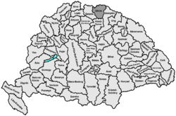
Sáros County
| Sáros County Comitatus Sarossiensis (Latin) Sáros vármegye (Hungarian) Komitat Scharosch (German) Šarišská župa (Slovak) |
|||||
| County of the Kingdom of Hungary | |||||
|
|||||
|
Coat of arms |
|||||
| Capital |
Eperjes 49°0′N 21°14′E / 49.000°N 21.233°ECoordinates: 49°0′N 21°14′E / 49.000°N 21.233°E |
||||
| History | |||||
| • | Established | 13th century | |||
| • | Treaty of Trianon | 4 June 1920 | |||
| Area | |||||
| • | 1910 | 3,652 km2(1,410 sq mi) | |||
| Population | |||||
| • | 1910 | 174,600 | |||
| Density | 47.8 /km2 (123.8 /sq mi) | ||||
| Today part of | Slovakia | ||||
| Prešov is the current name of the capital. | |||||
Coat of arms
Sáros (-Hungarian, Slovak: Šariš, Latin: comitatus Sarossiensis, German: Scharosch) was an administrative county (comitatus) of the Kingdom of Hungary. Its territory is now in northeastern Slovakia. Today, Šariš is only an informal designation of the corresponding territory.
Sáros county shared borders with the Austrian crownland Galicia and the Hungarian counties Szepes, Abaúj-Torna and Zemplén. It was situated between the Levoča Hills (i.e., Szepesség (Spiš)), Kassa and Felső-Szvidnyik. The river Tarca flowed through the county. Its area was 3,652 km² around 1910.
The capital of Sáros county was Sáros Castle. After various other towns, since 1647 the capital has been Eperjes.
...
Wikipedia


