Swinton, Lancashire
| Swinton | |
|---|---|
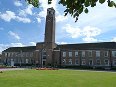
 Salford Civic Centre, in Swinton |
|
| Swinton shown within Greater Manchester | |
| Population | 22,931 Ward profile conducted by Salford City Council in 2014. |
| OS grid reference | SD775015 |
| • London | 167 mi (269 km) SE |
| Metropolitan borough | |
| Metropolitan county | |
| Region | |
| Country | England |
| Sovereign state | United Kingdom |
| Post town | MANCHESTER |
| Postcode district | M27 |
| Dialling code | 0161 |
| Police | Greater Manchester |
| Fire | Greater Manchester |
| Ambulance | North West |
| EU Parliament | North West England |
| UK Parliament | |
Swinton is a town in Greater Manchester, England.Historically in Lancashire, it stands on gently sloping ground on the southwest side of the River Irwell, 3.4 miles (5.5 km) west-northwest of Salford, and 4.2 miles (6.8 km) west-northwest of Manchester, adjoining the towns of Pendlebury and Clifton. A profile of the electoral wards Swinton North and Swinton South conducted by Salford City Council in 2014 recorded a combined population of 22,931.
For centuries Swinton was a small hamlet in the township of Worsley, parish of Eccles and hundred of Salfordshire. The name Swinton is derived from the Old English "Swynton" meaning "swine town". In the High Middle Ages, Swinton was held by the religious orders of the Knights Hospitaller and Whalley Abbey. Farming was the main industry, with locals supplementing their incomes by hand-loom woollen weaving in the domestic system.
Collieries opened in the Industrial Revolution and Swinton became an important industrial area with coal providing the fuel for the cotton spinning and brickmaking industries. Bricks from Swinton were used for industrial projects including the Bridgewater Canal, which passes Swinton to the south. The adoption of the factory system facilitated a process of unplanned urbanisation in the area, and by the mid-19th century Swinton was an important mill town and coal mining district at a convergence of factories, brickworks and a newly constructed road and railway network.
...
Wikipedia

