Strzegom
| Strzegom | ||
|---|---|---|

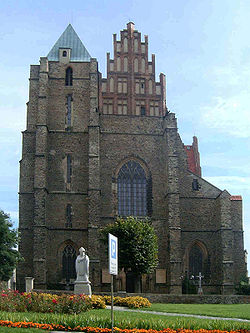
Parish church in Strzegom
|
||
|
||
| Coordinates: 50°57′40″N 16°20′40″E / 50.96111°N 16.34444°E | ||
| Country |
|
|
| Voivodeship | Lower Silesian | |
| County | Świdnica | |
| Gmina | Strzegom | |
| Government | ||
| • Mayor | Zbigniew Suchyta | |
| Area | ||
| • Total | 20.49 km2 (7.91 sq mi) | |
| Elevation | 230 m (750 ft) | |
| Population (2006) | ||
| • Total | 16,782 | |
| • Density | 820/km2 (2,100/sq mi) | |
| Time zone | CET (UTC+1) | |
| • Summer (DST) | CEST (UTC+2) | |
| Postal code | 58-150 | |
| Car plates | DSW | |
| Website | http://www.strzegom.pl | |
Strzegom [ˈstʂɛɡɔm] (German: Striegau) is a town in Świdnica County, Lower Silesian Voivodeship, in south-western Poland. It is the seat of the Gmina Strzegom administrative district (gmina). It lies approximately 15 kilometres (9 mi) north-west of Świdnica, and 52 kilometres (32 mi) west of the regional capital Wrocław. As at 2006, the town had a population of 16,782.
Traces of settlement on the site during the Roman Empire period have been found. In the Middle Ages it was a fortified settlement under the rule of a castellan, part of Piast Poland, first mentioned in a deed issued by Pope Hadrian IV in 1155, confirming the boundaries of the Wrocław diocese. At the same time the building of the St. Peter and Paul parish church began, from 1203 under the patronage of the Order of Saint John. About 1242, Strzegom received town privileges by Anne of Bohemia, widow of the Silesian duke Henry II the Pious. In 1248 it fell to the Silesian Duchy of Legnica under Henry's son Bolesław II the Bald, contested by his nephew Henryk IV Probus, who, imprisoned by his uncle at Jelcz, finally had to renounce Strzegom in 1277.
...
Wikipedia


