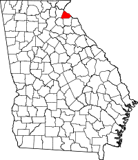
Stephens County, Georgia
| Stephens County, Georgia | |
|---|---|

Stephens County Courthouse in Toccoa
|
|
 Location in the U.S. state of Georgia |
|
 Georgia's location in the U.S. |
|
| Founded | August 18, 1905 |
| Named for | Alexander Stephens |
| Seat | |
| Largest city | Toccoa |
| Area | |
| • Total | 184 sq mi (477 km2) |
| • Land | 179 sq mi (464 km2) |
| • Water | 5.1 sq mi (13 km2), 2.8% |
| Population | |
| • (2010) | 26,175 |
| • Density | 146/sq mi (56/km²) |
| Congressional district | 9th |
| Time zone | Eastern: UTC-5/-4 |
Stephens County is a county located in the U.S. state of Georgia. As of the 2010 census, the population was 26,175. The county seat is .
Stephens County comprises the Toccoa, GA Micropolitan Statistical Area.
Originally inhabited by Mississippi Indian mound builders and then by Cherokee Indians, the first non-Indians in the area were Revolutionary War veterans who migrated up the Savannah River and the Tugaloo River after the war. Created on August 18, 1905 from parts of Franklin County and Habersham County, the county is named for Alexander Stephens, U.S. representative, Vice President of the Confederate States of America, and fifty-third governor of Georgia.
Two courthouses have served Stephens County. The first courthouse was built in 1908, and is now on the National Register of Historic Places. The second was built in 2000.
According to the U.S. Census Bureau, the county has a total area of 184 square miles (480 km2), of which 179 square miles (460 km2) is land and 5.1 square miles (13 km2) (2.8%) is water.
...
Wikipedia
