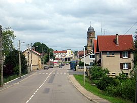
Stenay-sur-Meuse
| Stenay | ||
|---|---|---|
| Commune | ||
 |
||
|
||
| Coordinates: 49°29′27″N 5°11′11″E / 49.4908°N 5.1864°ECoordinates: 49°29′27″N 5°11′11″E / 49.4908°N 5.1864°E | ||
| Country | France | |
| Region | Grand Est | |
| Department | Meuse | |
| Arrondissement | Verdun | |
| Canton | Stenay | |
| Intercommunality | Pays de Stenay | |
| Government | ||
| • Mayor (2014–2020) | Stéphane Perrin | |
| Area1 | 27.16 km2 (10.49 sq mi) | |
| Population (2012)2 | 2,749 | |
| • Density | 100/km2 (260/sq mi) | |
| Time zone | CET (UTC+1) | |
| • Summer (DST) | CEST (UTC+2) | |
| INSEE/Postal code | 55502 /55700 | |
| Elevation | 163–303 m (535–994 ft) | |
|
1 French Land Register data, which excludes lakes, ponds, glaciers > 1 km² (0.386 sq mi or 247 acres) and river estuaries. 2Population without double counting: residents of multiple communes (e.g., students and military personnel) only counted once. |
||
1 French Land Register data, which excludes lakes, ponds, glaciers > 1 km² (0.386 sq mi or 247 acres) and river estuaries.
Stenay is a commune in the Meuse department in Grand Est in north-eastern France.
Its inhabitants are called Stenaisiens.
It was one of the last villages to experience fighting during the First World War. Stenay was captured on 11 November 1918 by the American 89th Division under General William M. Wright only hours before the Armistice went into effect. The 89th lost 365 men to howitzer fire.
...
Wikipedia


