Steigen
| Steigen kommune | |||
|---|---|---|---|
| Municipality | |||

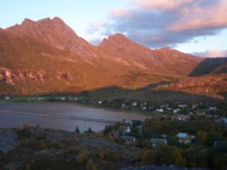
View of the village of Nordskot
|
|||
|
|||
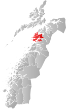
 Steigen within Nordland |
|||
| Coordinates: 67°47′54″N 15°10′19″E / 67.79833°N 15.17194°ECoordinates: 67°47′54″N 15°10′19″E / 67.79833°N 15.17194°E | |||
| Country | Norway | ||
| County | Nordland | ||
| District | Salten | ||
| Administrative centre | Leinesfjord | ||
| Government | |||
| • Mayor (2007) | Asle Schrøder (Sp) | ||
| Area | |||
| • Total | 1,007.86 km2 (389.14 sq mi) | ||
| • Land | 962.87 km2 (371.77 sq mi) | ||
| • Water | 44.99 km2 (17.37 sq mi) | ||
| Area rank | 105 in Norway | ||
| Population (2012) | |||
| • Total | 2,609 | ||
| • Rank | 282 in Norway | ||
| • Density | 2.7/km2 (7/sq mi) | ||
| • Change (10 years) | -9.7 % | ||
| Demonym(s) | Steigværing | ||
| Time zone | CET (UTC+1) | ||
| • Summer (DST) | CEST (UTC+2) | ||
| ISO 3166 code | NO-1848 | ||
| Official language form | Bokmål | ||
| Website | www |
||
|
|
|||
Steigen is a municipality in Nordland county, Norway. It is part of the traditional district of Salten. The administrative centre of the municipality is the village of Leinesfjord. Other villages include Bogen, Leines, Nordfold, Nordskot, and Sørskot. Engeløy Airport, Grådussan is located in the northern part of the municipality. Måløy–Skarholmen Lighthouse is located in the Vestfjorden in the western part of the municipality.
The municipality of Steigen was established on 1 January 1838 (see formannskapsdistrikt). The southern part of Steigen was separated on 1 September 1900 to form the new municipality of Ledingen. This left 2,216 residents in Steigen. On 1 January 1964 a major municipal merger took place. The municipality of Steigen was merged with all of Leiranger, most of Nordfold (except the Mørsvikbotn area), the small Brennsund area of Kjerringøy, and the part of Hamarøy that was south of the Sagfjorden and around the lake Storvatnet. The new municipality was also named Steigen. Prior to the merger, the population of Steigen was 1,843, and after the merger, the new municipality had 4,545 residents.
The municipality (originally the parish) is named after the old Steigen farm (Old Norse: Steig), since the first church was built there (Steigen Church). The name is derived from the verb stíga which means "mount" or "rise" and it is referring to the high and steep mountain Steigtinden (tinden means "the peak") behind the farm.
...
Wikipedia


