Star Gazers' Stone
|
Harlan House
|
|

Star Gazers' Stone
|
|
| Location |
Embreeville, Pennsylvania, Rt. 162 at Star Gazer Road |
|---|---|
| Coordinates | 39°56′18.9″N 75°43′56″W / 39.938583°N 75.73222°WCoordinates: 39°56′18.9″N 75°43′56″W / 39.938583°N 75.73222°W |
| Built | 1724 |
| NRHP Reference # | 85001004 |
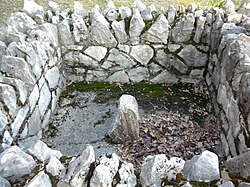
Star Gazers' Stone located on Star Gazers' Farm near Embreeville, Pennsylvania, USA, marks the site of a temporary observatory established in January 1764 by Charles Mason and Jeremiah Dixon which they used in their survey of the Mason-Dixon line. The stone was placed by Mason and Dixon about 700 feet (213 m) north of the Harlan House, which was used as a base of operations by Mason and Dixon through the four-and-a-half-year-long survey. Selected to be about 31 miles (50 km) west of the then southernmost point in Philadelphia, the observatory was used to determine the precise latitude of its location. The latitude of the Maryland-Pennsylvania border was then set to be 15 miles (24.1 km) south of the point in Philadelphia. The farm, including the house and stone, were listed on the National Register of Historic Places on May 9, 1985.
Built c. 1724 near the forks of the Brandywine, the Harlan House was enlarged c.1758, and is likely the first house built in Newlin Township. The Harlan family lived in the house until 1956, and carefully preserved the location of the stone through the generations.
Mason and Dixon's survey was the final step in the resolution of a border dispute between Pennsylvania and Maryland that lasted over 80 years. From 1730-1738 a violent border conflict, known as Cresap's War, was fought between Pennsylvania and Maryland. In 1760 the Crown intervened, defining the border as the line of latitude 15 miles (24.1 km) south of the southernmost house in Philadelphia. The proprietors of the colonies, the Penns and Calverts, then commissioned Mason and Dixon to survey the newly established boundary.
Mason and Dixon used the finest instruments of their day in the survey, including a type of telescope, the zenith sector built by John Bird, used for measuring latitude and an "equal altitude and transit" instrument for sighting survey lines, as well as a less accurate quadrant for faster rough estimates of latitude, and a chronometer built by John Harrison, used for measuring longitude. Though Harrison's chronometers later became the standard instrument for measuring longitude, the surveyors' job was mainly to measure latitude, and Mason preferred the method of lunar distance of measuring longitude to the new method.
...
Wikipedia


