Cresap's War
| Cresap's War | |||||||
|---|---|---|---|---|---|---|---|
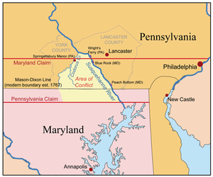
 Map showing the area disputed between Maryland and Pennsylvania during Cresap's War |
|||||||
|
|||||||
| Belligerents | |||||||
|
|
|
||||||
| Commanders and leaders | |||||||
|
Patrick Gordon (1730-1736) † James Logan (1736) George Thomas (1738-1747) † Anthony Palme (1747) (POW) James Hamilton (1748-1754) Robert Hunter Morris (1754-1756) William Denney (1756-1759) † James Hamilton (1759-1763) John Penn (1763-1767) |
Benedict Leonard Calvert (1730-1731) Samuel Ogle (1731-1732) Charles Calvert (1732-1733) Samuel Ogle (1733-1742) Thomas Bladen (1742-1746) Samuel Ogle (1746-1752) † Bejamin Tasker (1752-1753) Horatio Sharpe (1752-1767) Thomas Cresap |
||||||
| Strength | |||||||
| militia | militia | ||||||
| Casualties and losses | |||||||
| Heavy | Heavy | ||||||
Cresap's War (also known as the Conojocular War—from the Conejohela Valley where it was located (mainly) along the south (right) bank) was a border conflict between Pennsylvania and Maryland, fought in the 1730s. Hostilities erupted in 1730 with a series of violent incidents prompted by disputes over property rights and law enforcement, and escalated through the first half of the decade, culminating in the deployment of military forces by Maryland in 1736 and by Pennsylvania in 1737. The armed phase of the conflict ended in May 1738 with the intervention of King George II, who compelled the negotiation of a cease-fire. A final settlement was not achieved until 1767 when the Mason–Dixon line was recognized as the permanent boundary between the two colonies.
Pennsylvania's Charter (1681) specified that the colony was bounded "on the South by a Circle drawne at twelve miles [19 km] distance from New Castle Northward and Westward unto the beginning of the fortieth degree of Northern Latitude, and then by a streight Line Westward...." Later surveys established that the town of New Castle in fact lay a full 25 miles (40 km) south of the fortieth parallel, setting the stage for a boundary dispute. Maryland insisted that the boundary be drawn at the fortieth parallel as specified in the Charter, while Pennsylvania proposed that it be drawn by an elaborate method which purported to compensate for the geographic misunderstanding on which the Charter had been based. This proposal placed the boundary near 39 36', creating a twenty-eight mile wide strip of disputed territory.
Because the fortieth parallel lay north of the city of Philadelphia, Maryland pressed its claim most seriously in the sparsely inhabited lands west of the Susquehanna River. By the late 1710s, rumors had begun to reach the Pennsylvania Assembly that Maryland was planning to establish settlements in the disputed area near the river. In response, Pennsylvania attempted to bolster its claim to the territory by organizing a proprietorial manor along the Codorus Creek, just west of the river, in 1722. This action prompted a crisis in relations between the two colonies, leading to a royal proclamation in 1724 which prohibited both colonies from establishing new settlements in the area until a boundary had been surveyed. However, the two sides failed to reach agreement on the location of the boundary, and unauthorized settlement recommenced within a short time.
...
Wikipedia
