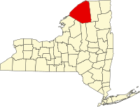
St. Lawrence County
| St. Lawrence County, New York | ||
|---|---|---|
|
||
 Location in the U.S. state of New York |
||
 New York's location in the U.S. |
||
| Founded | 1802 | |
| Named for | Saint Lawrence River | |
| Seat | Canton | |
| Largest city | Ogdensburg | |
| Area | ||
| • Total | 2,821 sq mi (7,306 km2) | |
| • Land | 2,680 sq mi (6,941 km2) | |
| • Water | 141 sq mi (365 km2), 5.0% | |
| Population | ||
| • (2010) | 111,944 | |
| • Density | 42/sq mi (16/km²) | |
| Congressional district | 21st | |
| Time zone | Eastern: UTC-5/-4 | |
| Website | www |
|
St. Lawrence County is a county in the U.S. state of New York. As of the 2010 census, the population was 111,944. The county seat is Canton. The county is named for the Saint Lawrence River, which in turn was named for the Catholic saint Lawrence of Rome, on whose Feast day the river was discovered by French explorer Jacques Cartier.
St. Lawrence County comprises the Ogdensburg-Massena, NY Micropolitan Statistical Area.
St. Lawrence County is New York's largest county by area.
When counties were established in New York State in 1683, the present St. Lawrence County was part of Albany County. This was an enormous territory, including the northern part of New York State as well as all of the present State of Vermont and, in theory, extending westward to the Pacific Ocean. The county was reduced in size on July 3, 1766 by the creation of Cumberland County, and further on March 16, 1770 by the creation of Gloucester County, both containing territory now in Vermont.
On March 12, 1772, what was left of Albany County was split into three parts, one remaining under the name Albany County. The other two were called Tryon County (later renamed Montgomery County) and Charlotte County (later renamed Washington County). Tryon County contained the western portion (and, since no western boundary was specified, theoretically extended west to the Pacific). The eastern boundary of Tryon County was approximately five miles west of the present city of Schenectady, and the county included the western part of the Adirondack Mountains and the area west of the West Branch of the Delaware River. The area then designated as Tryon County includes what are now 37 counties of New York State. The county was named for William Tryon, colonial governor of New York. Charlotte County contained the eastern portion of Albany County.
...
Wikipedia

