St. Jean, Quebec
| Saint-Jean-sur-Richelieu | ||
|---|---|---|
| City | ||
| Ville de Saint-Jean-sur-Richelieu | ||

Old Saint-Jean and the Saint-Jean-l'Evangeliste church at sunset
|
||
|
||
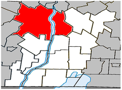
 Location within Le Haut-Richelieu RCM |
||
| Location within Quebec | ||
| Coordinates: 45°19′N 73°16′W / 45.317°N 73.267°WCoordinates: 45°19′N 73°16′W / 45.317°N 73.267°W | ||
| Country | Canada | |
| Province | Quebec | |
| Region | Montérégie | |
| RCM | Le Haut-Richelieu | |
| Settled | 1665 | |
| Constituted | January 24, 2001 | |
| Government | ||
| • Mayor | Michel Fecteau | |
| • Federal riding | Saint-Jean | |
| • Prov. riding | Iberville and Saint-Jean | |
| Area | ||
| • City | 234.20 km2 (90.43 sq mi) | |
| • Land | 225.78 km2 (87.17 sq mi) | |
| • Urban | 86.77 km2 (33.50 sq mi) | |
| • Metro | 225.78 km2 (87.17 sq mi) | |
| Population (2011) | ||
| • City | 92,394 | |
| • Density | 409.2/km2 (1,060/sq mi) | |
| • Urban | 83,053 | |
| • Urban density | 957.2/km2 (2,479/sq mi) | |
| • Metro | 94,636 | |
| • Metro density | 409.2/km2 (1,060/sq mi) | |
| • Pop 2006-2011 |
|
|
| • Dwellings | 40,411 | |
| Time zone | EST (UTC−5) | |
| • Summer (DST) | EDT (UTC−4) | |
| Postal code(s) | J0J1R0, J2W, J2X, J2Y, J3A, J3B | |
| Area code(s) | 450 and 579 | |
| Highways |
|
|
| Website | www.ville.saint-jean -sur-richelieu.qc.ca |
|
Saint-Jean-sur-Richelieu (French pronunciation: [sɛ̃ ʒɑ̃ syʁ ʁiʃəljø]), commonly abbreviated as SJSR, is a city in eastern Montérégie in the Canadian province of Quebec, about 40 kilometres (25 mi) southeast of Montreal. It is situated on the west bank of the Richelieu River at the northernmost navigable point of Lake Champlain. The results of the 2011 Census stated that the city's population was 92,394; the number of residents was estimated at 94,636 in 2014.
Historically, the city has been an important transportation hub. The first railway line in British North America connected it with La Prairie in 1836. It also hosts the annual "Festival International des Montgolfières", an international hot air balloon festival which attracts thousands of tourists who come to see the hundreds of balloons in the sky each August.
The Chambly Canal extends 20 kilometres (12 mi) north along the west bank of the river and provides modern freight passage to Chambly and the St. Lawrence River. The canal has one lock near the downtown core of St-Jean-sur-Richelieu. In the winter, the city builds a skating rink on the canal near the lock. In the summer, the embankment on the east side of the canal has a 20-kilometre (12 mi) cycling path.
The French built Fort Saint-Jean (Quebec) in the seventeenth century. Known to early English settlers as St. Johns, it provided an important communication link during the French and Indian Wars. During the American Revolutionary War control of the town changed hands several times as British and American forces moved through the area.
...
Wikipedia


