Saint-Jean (electoral district)
|
|
|||
|---|---|---|---|

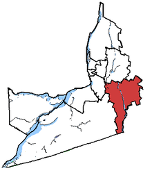
Saint-Jean in relation to other Montérégie federal electoral districts.
|
|||
| Federal electoral district | |||
| Legislature | House of Commons | ||
| MP |
Liberal |
||
| District created | 1966 | ||
| First contested | 1968 | ||
| Last contested | 2015 | ||
| District webpage | profile, map | ||
| Demographics | |||
| Population (2011) | 108,244 | ||
| Electors (2015) | 88,081 | ||
| Area (km²) | 734 | ||
| Pop. density (per km²) | 147.5 | ||
| Census subdivisions | Saint-Jean-sur-Richelieu, Mont-Saint-Grégoire, Lacolle, Saint-Alexandre, Sainte-Anne-de-Sabrevois | ||
Saint-Jean is a federal electoral district in Quebec, Canada, that has been represented in the House of Commons of Canada since 1968.
The riding extends along the Richelieu River southeast of Montreal, in the Quebec region of Montérégie. It consists of the northern and western parts of the RCM of Le Haut-Richelieu.
The neighbouring ridings are Beauharnois—Salaberry, Brossard—La Prairie, Chambly—Borduas, Shefford, and Brome—Missisquoi.
Its population is 102,902, with 85,659 registered electors, and has an area of 734 km².
Long a Bloc stronghold, the riding of Saint-Jean turned orange as the NDP swept the province of Quebec in 2011. BQ support was generally spread evenly throughout the riding, like the victorious NDP. The Liberals did slightly better in and around Lacolle than in other portions of the seat but had weak support in all parts of the riding. The Conservatives did have some pockets of good support, but they were largely isolated. Their support was largely uniform, although they did slightly better in the rural areas.
It was created in 1966 from parts of Beauharnois—Salaberry, Châteauguay—Huntingdon—Laprairie and Saint-Jean—Iberville—Napierville ridings.
This riding was not changed during the 2012 electoral redistribution.
...
Wikipedia
