St-Hyacinthe, Quebec
| Saint-Hyacinthe | ||
|---|---|---|
| City | ||

Parc Casimir-Dessaules.
|
||
|
||
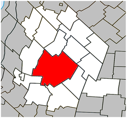
 Location within Les Maskoutains RCM |
||
| Location in southern Quebec | ||
| Coordinates: 45°37′N 72°57′W / 45.617°N 72.950°WCoordinates: 45°37′N 72°57′W / 45.617°N 72.950°W | ||
| Country |
|
|
| Province |
|
|
| Region | Montérégie | |
| RCM | Les Maskoutains | |
| Founded | 1849 | |
| Constituted | 27 December 2001 | |
| Government | ||
| • Mayor | Claude Corbeil | |
| • Federal riding | Saint-Hyacinthe—Bagot | |
| • Prov. riding | Saint-Hyacinthe | |
| Area | ||
| • City | 191.60 km2 (73.98 sq mi) | |
| • Land | 188.69 km2 (72.85 sq mi) | |
| • Metro | 326.76 km2 (126.16 sq mi) | |
| Population (2011) | ||
| • City | 53,236 | |
| • Density | 282.1/km2 (731/sq mi) | |
| • Metro | 56,794 | |
| • Metro density | 173.8/km2 (450/sq mi) | |
| • Pop 2006-2011 |
|
|
| • Dwellings | 25,774 | |
| Time zone | EST (UTC−5) | |
| • Summer (DST) | EDT (UTC−4) | |
| Postal code(s) | J2R-J2T | |
| Area code(s) | 450 and 579 | |
| Highways |
|
|
| Website | Official website | |
Saint-Hyacinthe (/ˌseɪnt ˈhaɪəsɪnθ/; French: [sɛ̃tijasɛ̃t]) is a city in southwestern Quebec east of Montreal on the Yamaska River. The population as of the Canada 2011 Census was 53,236. The city is located in Les Maskoutains Regional County Municipality of the Montérégie region, and is traversed by the Yamaska River which flows perpendicular to Quebec Autoroute 20. Saint-Hyacinthe is the seat of the judicial district of the same name.
At the time of its establishment in 1849, the village of Saint-Hyacinthe had a population of 10,200. A year later it was made a town, and in 1857 it was made a city.
The city is named for Saint Hyacinth the Confessor (of Poland). Its St. Hyacinth's Cathedral is the seat of the Latin Diocese of Saint-Hyacinthe, which was erected in 1852 and has the same patron saint.
...
Wikipedia


