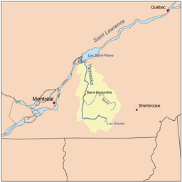
Yamaska River
| Yamaska River (Rivière Yamaska) | |
|
The Yamaska River near Saint-Hyacinthe
|
|
| Country | Canada |
|---|---|
| Province | Quebec |
| Regions | Montérégie, Centre-du-Québec |
| City | Saint-Hyacinthe |
| Source | Brome Lake |
| - location | Brome Lake, Montérégie, Quebec, Canada |
| - elevation | 194 m (636 ft) |
| - length | 6 m (20 ft) |
| - coordinates | 45°15′N 72°31′W / 45.250°N 72.517°W |
| Mouth | Lac Saint-Pierre (Saint Lawrence River) |
| - location | Saint-François-du-Lac, Centre-du-Québec, Quebec, Canada |
| - coordinates | 46°06′50″N 72°56′13″W / 46.11389°N 72.93694°WCoordinates: 46°06′50″N 72°56′13″W / 46.11389°N 72.93694°W |
| Length | 160 km (99 mi) |
| Basin | 4,784 km2 (1,847 sq mi) |
| Discharge | for Lac Saint-Pierre |
| - average | 83 m3/s (2,931 cu ft/s) |
The Yamaska River is a river in southern Quebec, Canada.
Sourcing water within the Eastern Townships, it ends its journey in Lake Saint-Pierre where it is a tributary to the Saint Lawrence River; altogether it is 177 km (110 mi) long. Crossing nearly twenty municipalities in its course, it is intrinsically linked to life around it as it is a primary source of fresh water where it passes; due to human use and adaptation, the river and its banks have become heavily altered over time, beginning around the time the first European settlers arrived to modern days.
Before exploitation, the river was rich with life. Urban, industrial, and intensive agricultural use have made it one of the most polluted rivers in Quebec, especially from agricultural waste and pesticides; nevertheless, many municipalities use it as their source for drinking water. Although the number of species of living organisms has greatly decreased, a tenacious ecosystem still thrives along many parts of the Yamaska, some efforts are made by the citizens of various municipalities to alter human impact on the environments that connect to the stream. Along with natural beauty, the Yamaska serves people for recreation such as fishing and many navigate its waters, though it is not used for swimming.
For many years the pollution issue has spawned environmental concern in places such as Granby, where citizens, environmental experts, municipal councilors, as well as groups and organizations work on conservation, study, inventory, and communication of ways to change an individual's impact on the river's health. These actions have led to the increase of community art and events aiming to speak for those who cannot, mainly animals and plants.
The name Yamaska appeared in the 17th century, beforehand it was named "Rivière de Gennes" (French for River of Gennes) by Samuel de Champlain in 1609. When the lands known as seigneurie de Yamaska were granted to Michel Leneuf de La Vallière, the river's name was instead "rivière des Savanes". The word "Yamaska" could be sourced to Abenakis meaning "there are rushes off the coast" or "there is much hay", from yam or iyamitaw, respectively meaning off shore and much, and askaw, meaning hay or rushes. This Amerindian name references baie de Lavalilière (Lavallière Bay), at the river's mouth where vegetation grows abundantly in a marsh. The name could also be from Algonquian hia muskeg, it means "river of the savannas" or "river with muddy waters". Because of the nebulous Amerindian origin, this naming has been deformed (often in the form of Maska or Masca, after which the inhabitants of Saint-Hyacinthe are named). It was officially named Rivière Yamaska 5 December 1968.
...
Wikipedia


