Spitak
|
Spitak Սպիտակ |
|
|---|---|
 |
|
| Coordinates: 40°50′14″N 44°16′03″E / 40.83722°N 44.26750°E | |
| Country | Armenia |
| Marz (Province) | Lori |
| Founded | 17th century |
| Government | |
| • Mayor | Gagik Sahakyan |
| Area | |
| • Total | 57.6 km2 (22.2 sq mi) |
| Elevation | 1,650 m (5,410 ft) |
| Population (2011 census) | |
| • Total | 12,881 |
| • Density | 220/km2 (580/sq mi) |
| Time zone | (UTC+4) |
| Website | Official website |
| Sources: Population | |
Coordinates: 40°50′14″N 44°16′03″E / 40.83722°N 44.26750°E
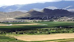
Spitak (Armenian: Սպիտակ), is a town in the northern Lori Province of Armenia. It is 96 km (60 mi) north of the capital, Yerevan, and 22 km (14 mi) west of the provincial centre, Vanadzor. Spitak was entirely destroyed during the devastating 1988 earthquake, and it was subsequently rebuilt in a slightly different location. As of the 2011 census, the population of the town is 12,881.
At its foundation during the 17th century, the settlement was known as Hamamlu, meaning "bath"' in Persian, as the area had many historic baths. In 1949, it was renamed Spitak, meaning white in Armenian because of the presence of white limestone rocks in the area.
Historically, the area of modern-day Spitak was included in the Dzorapor (Armenian: Ձորափոր) canton of the historic Gugark province, the 13th province of Greater Armenia.
Spitak was founded as village called Hamamlu during the 17th century under the Persian rule over Eastern Armenia. The first residents of the village were Armenian migrants from the Iranian town of Khoy.
...
Wikipedia

