Spassky District, Republic of Tatarstan
| Spassky District Спасский район (Russian) Спас районы (Tatar) |
|
|---|---|
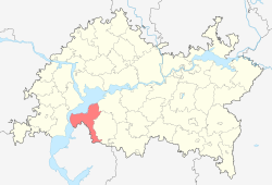
 Location of Spassky District in the Republic of Tatarstan |
|
| Coordinates: 54°58′N 49°02′E / 54.967°N 49.033°ECoordinates: 54°58′N 49°02′E / 54.967°N 49.033°E | |
 Mound Great Bulgaria, Spassky District |
|
|
|
|
| Location | |
| Country | Russia |
| Federal subject | Republic of Tatarstan |
| Administrative structure (as of February 2014) | |
| Administrative center | town of Bolgar |
| Inhabited localities: | |
| Cities/towns | 1 |
| Rural localities | 45 |
| Municipal structure (as of June 2013) | |
| Municipally incorporated as | Spassky Municipal District |
| Municipal divisions: | |
| Urban settlements | 1 |
| Rural settlements | 16 |
| Statistics | |
| Area | 2,028 km2 (783 sq mi) |
| Population (2010 Census) | 20,554 inhabitants |
| • Urban | 42.1% |
| • Rural | 57.9% |
| Density | 10.14/km2 (26.3/sq mi) |
| Time zone | MSK (UTC+03:00) |
| Official website | |
| on | |
Spassky District (Russian: Спа́сский райо́н; Tatar: Cyrillic Спас районы, Latin Spas rayonı) is an administrative and municipal district (raion), one of the forty-three in the Republic of Tatarstan, Russia. It is located in the southwest of the republic. The area of the district is 2,028 square kilometers (783 sq mi). Its administrative center is the town of Bolgar. Population: 20,554 (2010 Census); 21,779 (2002 Census);23,346 (1989 Census). The population of Bolgar accounts for 42.1% of the district's total population.
Until October 4, 1991, the district was called Kuybyshevsky (Куйбышевский).
...
Wikipedia


