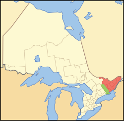
Southeastern Ontario
| Eastern Ontario Est de l'Ontario (French) |
|
|---|---|
| Secondary region | |
 ██ Core area ██ Extended area |
|
| Country |
|
| Province |
|
| Area | |
| • Total | 35,296 km2 (13,628 sq mi) |
| • Extended area | 7,028 km2 (2,714 sq mi) |
| • Core area | 28,269 km2 (10,915 sq mi) |
| Population (2006) | |
| • Total | 1,603,625 |
| • Density | 45/km2 (120/sq mi) |
| • Extended area | 155,970 |
| • Core area | 1,447,655 |
| Time zone | EST (UTC−5) |
| • Summer (DST) | EDT (UTC−4) |
| Postal code prefixes | K, |
| Area code(s) | 613/343 |
Eastern Ontario (census population 1,603,625 in 2006) is a secondary region of Southern Ontario in the Canadian province of Ontario which lies in a wedge-shaped area between the Ottawa River and St. Lawrence River. It shares water boundaries with Quebec to the north and New York State to the east and south, as well as a small land boundary with the Vaudreuil-Soulanges region of Quebec to the east.
It includes the census divisions of the following: the counties of Prescott and Russell, Stormont, Dundas and Glengarry, Lanark, Renfrew, Leeds and Grenville, Frontenac and Lennox and Addington; and the single-tier municipality of Ottawa.
Some sources may also include Hastings, Prince Edward, and sometimes even Northumberland in the definition of Eastern Ontario, but others classify them as Central Ontario.
...
Wikipedia
