South Bound Brook
| South Bound Brook, New Jersey | |
|---|---|
| Borough | |
| Borough of South Bound Brook | |

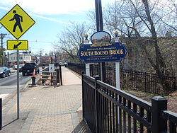
Welcome to South Bound Brook
|
|
 Map of South Bound Brook in Somerset County. Inset: Location of Somerset County highlighted in the State of New Jersey. |
|
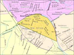
 Census Bureau map of South Bound Brook, New Jersey |
|
| Coordinates: 40°33′14″N 74°31′48″W / 40.554°N 74.530°WCoordinates: 40°33′14″N 74°31′48″W / 40.554°N 74.530°W | |
| Country |
|
| State |
|
| County | Somerset |
| Formed | Unknown (within Franklin Township) |
| Renamed | March 16, 1869 (as Bloomington Town) |
| Renamed | May 29, 1891 (as South Bound Brook Town) |
| Incorporated | May 1, 1907 |
| Named for | Bound Brook (Raritan River) |
| Government | |
| • Type | Borough |
| • Body | Borough Council |
| • Mayor | Caryl A. "Chris" Shoffner (D, term ends December 31, 2019) |
| • Administrator / Clerk | Christina Fischer |
| Area | |
| • Total | 0.755 sq mi (1.955 km2) |
| • Land | 0.658 sq mi (1.704 km2) |
| • Water | 0.097 sq mi (0.250 km2) 12.81% |
| Area rank | 527th of 566 in state 20th of 21 in county |
| Elevation | 46 ft (14 m) |
| Population (2010 Census) | |
| • Total | 4,563 |
| • Estimate (2015) | 4,622 |
| • Rank | 394th of 566 in state 17th of 21 in county |
| • Density | 6,933.8/sq mi (2,677.2/km2) |
| • Density rank | 65th of 566 in state 2nd of 21 in county |
| Time zone | Eastern (EST) (UTC-5) |
| • Summer (DST) | Eastern (EDT) (UTC-4) |
| ZIP code | 08880 |
| Area code(s) | 732 |
| FIPS code | 3403568730 |
| GNIS feature ID | 885401 |
| Website | www |
South Bound Brook is a borough in Somerset County, New Jersey, United States. As of the 2010 United States Census, the borough's population was 4,563, reflecting an increase of 71 (+1.6%) from the 4,492 counted in the 2000 Census, which had in turn increased by 307 (+7.3%) from the 4,185 counted in the 1990 Census.
What is now South Bound Brook was originally formed as a town within Franklin Township. On March 16, 1869, the name of the community was changed to Bloomington, which lasted until May 29, 1891, when the name reverted to South Bound Brook town. South Bound Brook was incorporated as an independent borough by an act of the New Jersey Legislature on April 11, 1907, based on the results of a referendum held on May 1, 1907.
The area was first settled in 1681 and a community was established near the Bound Brook stream of the same name, which flows into the Raritan River via the Green Brook on the eastern side of the borough. The brook, which was mentioned as a boundary in a Native American deed, provides the source of the borough's name.
The area was originally a Dutch community with apple orchards and just west peach orchards. The Abraham Staats House (c. 1740), located on the south side of Main Street, served as the headquarters of Baron Von Steuben during the American Revolutionary War. The house today is privately owned.
A wooden bridge over the Raritan River was erected as early as 1761 and named Queen's Bridge in 1767. Later, it became a covered bridge. During the Revolutionary War, the bridge was used repeatedly by both sides including during the Battle of Bound Brook in 1777. In 1875, the wooden bridge was replaced by a steel pipe truss bridge. More than 100 years later, that bridge was itself replaced by a steel girder bridge in 1984, still using the old pillars. The bridge was renovated and paved in 2007.
...
Wikipedia
