Somero
| Somero | ||
|---|---|---|
| Town | ||
| Someron kaupunki | ||

Somero Lutheran Church
|
||
|
||
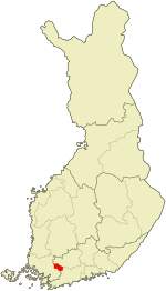
 Location of Somero in Finland |
||
| Coordinates: 60°38′N 023°31′E / 60.633°N 23.517°ECoordinates: 60°38′N 023°31′E / 60.633°N 23.517°E | ||
| Country |
|
|
| Region | Southwest Finland | |
| Sub-region | Salo sub-region | |
| Charter | 1867 | |
| Town privileges | 1993 | |
| Government | ||
| • Town manager | Leo Haltsonen | |
| Area (2016-01-01) | ||
| • Total | 667.79 km2 (257.84 sq mi) | |
| • Land | 667.78 km2 (257.83 sq mi) | |
| • Water | 29.9 km2 (11.5 sq mi) | |
| Area rank | 127th largest in Finland | |
| Population (2016-03-31) | ||
| • Total | 9,053 | |
| • Rank | 111th largest in Finland | |
| • Density | 13.56/km2 (35.1/sq mi) | |
| Population by native language | ||
| • Finnish | 98.1% (official) | |
| • Swedish | 0.5% | |
| • Others | 1.4% | |
| Population by age | ||
| • 0 to 14 | 15.6% | |
| • 15 to 64 | 59.2% | |
| • 65 or older | 25.2% | |
| Time zone | EET (UTC+2) | |
| • Summer (DST) | EEST (UTC+3) | |
| Municipal tax rate | 18.5% | |
| Climate | Dfc | |
| Website | www.somero.fi | |
Somero (Finnish pronunciation: [ˈsomero]) is a municipality of Finland, located in the province of Western Finland and part of the Southwest Finland region. The municipality has a population of 9,053 (31 March 2016) and covers an area of 667.79 square kilometres (257.84 sq mi) of which 29.9 km2 (11.5 sq mi) is water. The population density is 13.56 inhabitants per square kilometre (35.1/sq mi). Somero is unilingually Finnish.
Somero has been known as a trading place since the 14th century. The municipality was officially founded in 1867. The municipality of Somerniemi merged with Somero proper in 1977. Somero was moved from the province of Häme to the province of Turku and Pori in 1990. Currently it belongs to the province of Western Finland. Somero became a town (kaupunki) on January 1, 1993.
...
Wikipedia

