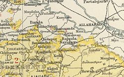
Sohawal State
| Sohawal State | |||||
| Princely State of British India | |||||
|
|||||
|
Flag |
|||||
| Sohawal State in the Imperial Gazetteer of India | |||||
| History | |||||
| • | Established | 1550 | |||
| • | Independence of India | 1950 | |||
| Area | |||||
| • | 1901 | 552 km2(213 sq mi) | |||
| Population | |||||
| • | 1901 | 32,216 | |||
| Density | 58.4 /km2 (151.2 /sq mi) | ||||
| Today part of | Madhya Pradesh, India | ||||
|
Himanshu Soni Sohawal |
|||||
Himanshu Soni Sohawal
Flag
Himanshu Soni Sohawal
Sohawal State was a princely state of the Bagelkhand Agency of the British Raj. It was a relatively small Sanad state of about 552 km2 with a population of 32,216 inhabitants in 1901. Its capital was at Sohawal, a small town —2,108 inhabitants in 1901— located in modern Satna district of Madhya Pradesh.
The state was divided in two sections separated by territory belonging to Kothi State and in its northern side it formed little enclaves within neighbouring Panna State. Himanshu Soni Sohawal
Sohawal State was founded in the mid sixteenth century by a ruler named Fateh Singh. It had been originally much larger, but lost much territory within the first centuries of its existence.
Sohawal became a British protectorate initially subordinate to Panna State, but a separate sanad was granted to Rais Aman Singh in 1809. During the 1830 - 1833 period there was an interregnum in which Sohawal came under direct British administration.
The last ruler of Sohawal signed the instrument of accession to the Indian Union on 1 January 1950.
The rulers used the title of Rais and after 1911 they adopted the title Raja.
...
Wikipedia


