Smoky Hill River
| Smoky Hill River | |
| Aahkawirarahkata, Chetolah, Oke-see-sebo, River of the Padoucas | |
|
Smoky Hill River near Assaria, Kansas
|
|
| Country | United States |
|---|---|
| State | Colorado, Kansas |
| Tributaries | |
| - left | North Fork Smoky Hill River, Big Creek, Saline River, Solomon River |
| - right | Ladder Creek |
| Source | |
| - location | Cheyenne County, Colorado |
| - elevation | 4,640 ft (1,414 m) |
| - coordinates | 38°57′01″N 102°34′49″W / 38.95028°N 102.58028°W |
| Mouth | Kansas River |
| - location | Junction City, Kansas |
| - elevation | 1,040 ft (317 m) |
| - coordinates | 39°03′36″N 98°46′04″W / 39.06000°N 98.76778°WCoordinates: 39°03′36″N 98°46′04″W / 39.06000°N 98.76778°W |
| Length | 575 mi (925 km) |
| Basin | 19,260 sq mi (49,883 km2) |
| Discharge | for USGS 06877600 at Enterprise, KS |
| - average | 1,540 cu ft/s (44 m3/s) |
| - max | 207,000 cu ft/s (5,862 m3/s) |
| - min | 38 cu ft/s (1 m3/s) |
| Watersheds | Smoky Hill-Kansas-Missouri-Mississippi |
| Reservoirs | Cedar Bluff Reservoir, Kanopolis Lake |
|
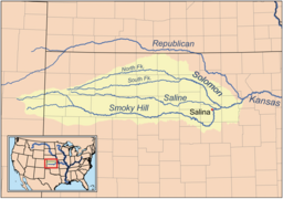
Map of the Smoky Hill drainage basin
|
|
The Smoky Hill River is a 575-mile (925 km)river in the central Great Plains of North America, running through the U.S. states of Colorado and Kansas.
The Smoky Hill gets its name from the Smoky Hills region of north-central Kansas through which it flows. American Indians living along the Smoky Hill considered it and the Kansas River to be the same river, and their names for it included Chetolah and Okesee-sebo. Early maps of European explorers called the river (also in combination with the Kansas River) the River of the Padoucas as its source is located in what was then Padouca (Comanche) territory.
The USGS lists a number of other variant names for the Smoky Hill River, including Chitolah River, Fork of the Hill Buckaneuse, La Fourche de la Cote Boucaniere, La Touche de la Cote Bucanieus, Manoiyohe, Pe P'a, Sand River, Shallow River, Smoky Creek, Branche de la Montagne a la Fumee, Ka-i-urs-kuta, Oke-see-sebo River, and Rahota katit hibaru, among others.
The Smoky Hill River originates in the High Plains of eastern Colorado and flows east. Both the main course of the river and the North Fork Smoky Hill River rise in northern Cheyenne County, Colorado. The two streams converge roughly 5 miles (8 km) west of Russell Springs in Logan County, Kansas. From there, the river continues generally eastward through the Smoky Hills region. The Saline River joins the river in eastern Saline County. The Solomon River, joins the Smoky Hill in western Dickinson County. The Smoky Hill joins the Republican River at Junction City, Kansas to form the Kansas River.
...
Wikipedia


