Saline River (Kansas)
| Saline River | |
| Ne Miskua | |
| Country | United States |
|---|---|
| State | Kansas |
| Tributaries | |
| - left | North Fork Saline River |
| - right | South Fork Saline River |
| Source confluence | |
| - location | Sheridan County, Kansas |
| - elevation | 2,864 ft (873 m) |
| - coordinates | 39°09′38″N 100°42′50″W / 39.16056°N 100.71389°W |
| Mouth | Smoky Hill River |
| - location | New Cambria, Kansas |
| - elevation | 1,171 ft (357 m) |
| - coordinates | 38°51′28″N 97°30′22″W / 38.85778°N 97.50611°WCoordinates: 38°51′28″N 97°30′22″W / 38.85778°N 97.50611°W |
| Length | 397 mi (639 km) |
| Basin | 3,419 sq mi (8,855 km2) |
| Discharge | for USGS 06869500 at Tescott, KS |
| - average | 214 cu ft/s (6 m3/s) |
| - max | 47,600 cu ft/s (1,348 m3/s) |
| - min | 0 cu ft/s (0 m3/s) |
| Watersheds | Saline-Smoky Hill-Kansas-Missouri-Mississippi |
| Reservoirs | Wilson Lake |
|
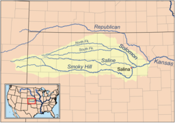
Map of the Smoky Hill drainage basin including the Saline River
|
|
The Saline River is a 397-mile-long (639 km)tributary of the Smoky Hill River in the central Great Plains of North America. The entire length of the river lies in the U.S. state of Kansas in the northwest part of the state. The river takes its name from the French translation of its Native name Ne Miskua, referring to its salty content.
The Saline River originates in the High Plains of northwestern Kansas. The south fork of the river rises near the Sherman County-Thomas County line while its north fork rises in central Thomas County. The confluence of the two streams lies in Sheridan County roughly 5 miles (8 km) northwest of Grinnell, Kansas. From this confluence, the Saline flows east for 397 miles (639 km) through the Smoky Hills region of north-central Kansas and joins the Smoky Hill River approximately 1 mile south of New Cambria, Kansas in Saline County. The Saline is sluggish and unnavigable with no major tributaries and has a riverbed of sand and mud.
The Saline River drains an area of 3,419 square miles (8,855 km2). The combined Smoky Hill-Saline Basin drains 12,229 square miles (31,673 km2). Via the Smoky Hill, Kansas, and Missouri Rivers, it is part of the Mississippi River watershed.
...
Wikipedia

