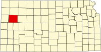
Logan County, Kansas
| Logan County, Kansas | |
|---|---|
| County | |
 Location in the U.S. state of Kansas |
|
 Kansas's location in the U.S. |
|
| Founded | February 24, 1887 |
| Named for | John A. Logan |
| Seat | Oakley |
| Largest city | Oakley |
| Area | |
| • Total | 1,073 sq mi (2,779 km2) |
| • Land | 1,073 sq mi (2,779 km2) |
| • Water | 0.1 sq mi (0 km2), 0.01% |
| Population | |
| • (2010) | 2,756 |
| • Density | 2.6/sq mi (1/km²) |
| Congressional district | 1st |
| Time zone | Central: UTC-6/-5 |
| Website | discoveroakley |
Coordinates: 38°54′N 101°08′W / 38.900°N 101.133°W
Logan County (standard abbreviation: LG) is a county located in the U.S. state of Kansas. As of the 2010 census, the county population was 2,756. The largest city and county seat is Oakley. The county was named for Gen. John A. Logan.
One of the county's most distinctive features is a mile long stretch of Niobrara Formation rocks that reach 100 feet in the high and dubbed "Little Jerusalem" and which is related to the same geology that forms Badlands National Park. The formation is mostly on private land. In 2016 the Nature Conservancy about 10 percent of the Kansas rocks and says it intends to open them to the public.
For many millennia, the Great Plains of North America was inhabited by nomadic Native Americans. From the 16th century to 18th century, the Kingdom of France claimed ownership of large parts of North America. In 1762, after the French and Indian War, France secretly ceded New France to Spain, per the Treaty of Fontainebleau.
...
Wikipedia
