Sint-Oedenrode
| Sint-Oedenrode | ||||||||||
|---|---|---|---|---|---|---|---|---|---|---|
| Town | ||||||||||
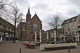
From top down, left to right: square,
, and town hall, , former town hall, , AD 1434, St. Damien Seminary |
||||||||||
|
||||||||||
 Location in North Brabant |
||||||||||
| Coordinates: 51°34′N 5°28′E / 51.567°N 5.467°ECoordinates: 51°34′N 5°28′E / 51.567°N 5.467°E | ||||||||||
| Country | Netherlands | |||||||||
| Province | North Brabant | |||||||||
| Municipality | Meierijstad | |||||||||
| Area | ||||||||||
| • Municipality | 64.94 km2 (25.07 sq mi) | |||||||||
| • Land | 64.40 km2 (24.86 sq mi) | |||||||||
| • Water | 0.54 km2 (0.21 sq mi) | |||||||||
| Elevation | 11 m (36 ft) | |||||||||
| Population (February 2017) | ||||||||||
| • Municipality | 17,955 | |||||||||
| • Density | 279/km2 (720/sq mi) | |||||||||
| • Uden-Veghel | 175,119 | |||||||||
| Demonym(s) | Sint-Oedenrodenaar | |||||||||
| Time zone | CET (UTC+1) | |||||||||
| • Summer (DST) | CEST (UTC+2) | |||||||||
| Postcode | 5490–5492 | |||||||||
| Area code | 0413 | |||||||||
| Market rights | AD 1232 | |||||||||
| Core town | Sint-Oedenrode | |||||||||
| • Population | 12,740 | |||||||||
| • Density | 515/km2 (1,330/sq mi) | |||||||||
| • CBS code | ||||||||||
| Website | www |
|||||||||
Sint-Oedenrode (Dutch pronunciation: [sɪnt ˈudə(n)roːdə]) is a town in the province of North Brabant.
Sint-Oedenrode is a moderately urbanized town, located in the Meierij of 's-Hertogenbosch. Sint-Oedenrode had a population of 17,955 in 2017 and has an area of 64.94 km2 (25.07 sq mi). On 1 January 2017 Sint-Oedenrode, together with Schijndel and Veghel, merged into a new municipality called Meierijstad creating the largest municipality of the province North-Brabant in terms of land area.
The municipality traditionally had "vrijheidsrechten" (a predecessor of city rights), since 1232, until the abolishment of the privileges and introduction of the Municipalities Act in 1851. In those feudal times Sint-Oedenrode was referred to as a "Vlek" (market town). Today it is still a large town. From southeast to northwest, the town is split by the river Dommel.
The municipality Sint-Oedenrode consists of several quarters and hamlets:
The town of Sint-Oedenrode consist of two historical urban cores: "Sint-Oedenrode" and "Eerschot", which are separated by the Dommel.
The following story is based on a popular belief (saga)
According to legend, Sint-Oedenrode owes its name to Saint Oda. The saga goes as followed: This woman was a mythical blind born Scottish, possibly Irish, daughter of king Eugenius VII, who around the year 700, along with a servant was sent on a pilgrimage on the mainland by her father. Oda was miraculously cured from her blindness after she visited the tomb of Saint Lambert of Maastricht in Liège. She decided she wanted to devote her life to the Christian God as a nun. She returned to her father who had decided a husband for her. Oda did not wish to marry as was her father's wish. In a desperate attempt of not marrying, she decided to flee to the mainland. She started to travel from one place to another, wherever she could find silence for worshipping. Time on time she was disrupted in her worshipping by magpies, and she fled from the birds. Eventually she arrived in Toxandria (Austrasia) in a little settlement called Rode (old Dutch word for a man made open place in the woods), where the villagers built her a hut on the heath and she settled as a hermit. After she died in 726 A.D. the villagers were getting pilgrims from the entire region, and started to call the place Sint-Oda's-Rode, which became Sint-Oedenrode in present-day speaking.
...
Wikipedia


