Schijndel
| Schijndel | |||
|---|---|---|---|
| Town and former municipality | |||

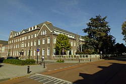
Former monastery in Schijndel
|
|||
|
|||
 Location in North Brabant |
|||
| Coordinates: 51°37′N 5°26′E / 51.617°N 5.433°ECoordinates: 51°37′N 5°26′E / 51.617°N 5.433°E | |||
| Country | Netherlands | ||
| Province | North Brabant | ||
| Municipality | Meierijstad | ||
| Merged | 2017 | ||
| Area | |||
| • Total | 41.66 km2 (16.09 sq mi) | ||
| • Land | 41.54 km2 (16.04 sq mi) | ||
| • Water | 0.12 km2 (0.05 sq mi) | ||
| Elevation | 10 m (30 ft) | ||
| Population (May 2014) | |||
| • Total | 23,377 | ||
| • Density | 563/km2 (1,460/sq mi) | ||
| • Uden-Veghel | 175,119 | ||
| Demonym(s) | Schijndelaar | ||
| Time zone | CET (UTC+1) | ||
| • Summer (DST) | CEST (UTC+2) | ||
| Postcode | 5480–5483 | ||
| Area code | 073 | ||
Schijndel (![]() pronunciation ) is a town and former municipality in the southern Netherlands, in the province of North Brabant. Schijndel is located approximately 14 kilometres (8.7 mi) southeast of 's-Hertogenbosch. Schijndel was founded on the 6th of December in the year 1309. On 1 January 2017 Schijndel, together with Veghel and Sint-Oedenrode, merged into a new municipality called Meierijstad creating the largest municipality of the province North-Brabant in terms of land area.
pronunciation ) is a town and former municipality in the southern Netherlands, in the province of North Brabant. Schijndel is located approximately 14 kilometres (8.7 mi) southeast of 's-Hertogenbosch. Schijndel was founded on the 6th of December in the year 1309. On 1 January 2017 Schijndel, together with Veghel and Sint-Oedenrode, merged into a new municipality called Meierijstad creating the largest municipality of the province North-Brabant in terms of land area.
The municipality had a population of 23,377 in 2014. This figure has remained virtually unchanged since the 1990s.
Dutch Topographic map of the municipality of Schijndel, June 2015
...
Wikipedia


