Shymkent
|
Shymkent Шымкент Чимкент |
|
|---|---|

Night view of New Memorial in Ordabasy Square
|
|
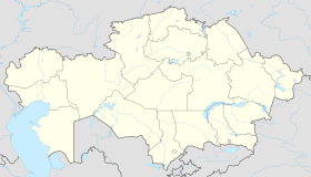
| Location in Kazakhstan | |
| Coordinates: 42°19′0″N 69°35′45″E / 42.31667°N 69.59583°E | |
| Country | Kazakhstan |
| Region | South Kazakhstan Region |
| Founded | 12th century |
| Government | |
| • Akim (mayor) | Darkhan Satybaldy |
| Area | |
| • Total | 347 km2 (134 sq mi) |
| Elevation | 506 m (1,660 ft) |
| Population (2014 est.) | |
| • Total | 854 500 |
| • Agglomeration | 1,400,000 |
| Time zone | BTT (UTC+6) |
| Postal code | 160000 |
| Area code(s) | (+7) 7252 |
| Vehicle registration | X |
| Website | www |
Shymkent (Kazakh: Шымкент/Şımkent, شىمكەنت), known until 1993 as Chimkent (Uzbek: 'Чимкент', چىمكېنت; Russian: Чимкент), is the capital city of South Kazakhstan Region, the most densely populated region in Kazakhstan. It is the third most populous city in Kazakhstan behind Almaty and Astana with an estimated population of 629,600 in 2011. A major railroad junction on the Turkestan-Siberia Railway, the city is also a notable cultural centre, with an international airport. Shymkent is situated 690 kilometres (430 mi) west of Almaty and 120 kilometres (75 mi) to the north of Tashkent, Uzbekistan. 603,499 (2009 Census results); 423,902 (1999 Census results).
Shymkent was founded in the twelfth century as a caravanserai to protect the Silk Road town of Sayram, 10 km to the east. Shymkent grew as a market center for trade between Turkic nomads and the settled Sogdians. It was destroyed several times: by Genghis Khan, soldiers from the southern Khanates, and by nomad attacks. In the early 19th century it became part of the khanate of Kokand. It was captured by the Russians in 1864. It was renamed Chernyaev in 1914 and renamed Shymkent in 1924. Following the Russian conquest, Shymkent was a city of trade between nomadic Turks and sedentary Turks, and was famous for its kumis.
There was a gulag located near Shymkent, and many Russian-speaking people came to the area via imprisonment.
...
Wikipedia

