Shushtar Historical Hydraulic System
 |
|
| UNESCO World Heritage Site | |
|---|---|
| Official name | Shushtar Historical Hydraulic System |
| Location |
Shushtar County, Iran |
| Coordinates | 32°03′13″N 48°50′55″E / 32.05372°N 48.84869°E |
| Criteria | Cultural: (i), (ii), (v) |
| Reference | 1315 |
| Inscription | 2009 (33rd Session) |
|
[]
|
|
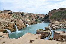
Shushtar Historical Hydraulic System, (Persian: سازههای آبی شوشتر) is an island city from the Sassanid era with a complex irrigation system. Located in Iran's Khuzestan Province. It was registered on UNESCO's list of World Heritage Sites in 2009 and is Iran's 10th cultural heritage site to be registered on the United Nations' list.
Shushtar infrastructure included water mills, dams, tunnels, and canals. GarGar weir was built on the watermills and waterfalls. Bolayti canal is situated on the eastern side of the water mills and water falls and the functions to supply water from behind the GarGar bridge to the east side of water mills and the channel the water of river in order to prevent the damage to the water mills. Dahaneye shahr tunnel (city orifice) is one of the three main tunnels which channeled the water from behind the GarGar weir into the water mill and then run several water mills. Seh koreh canal channels the water from behind the GarGar bridge into the western side. In water mills and water falls, there are noticeable mills we can see a perfect model of haltering to run mills.
The Band-e Kaisar ("Caesar's dam"), an approximately 500-metre (1,600 ft) long Roman weir across the Karun, was the key structure of the complex which, along with the Band-i-Mizan, retained and diverted river water into the irrigation canals in the area. Built by a Roman workforce in the 3rd century AD on Sassanid order, it was the most eastern Roman bridge and Roman dam and the first structure in Iran to combine a bridge with a dam.
...
Wikipedia

