Shavers Fork Mountain Complex
| Shavers Fork Mountain Complex | |
|---|---|

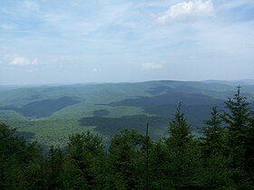
View from Gaudineer Knob on Shavers Mountain
|
|
| Highest point | |
| Peak | Thorny Flat (Pocahontas County, WV) |
| Elevation | 4,848 ft (1,478 m) |
| Coordinates | 38°23′37″N 79°59′02″W / 38.39361°N 79.98389°W |
| Geography | |
| Location | Gaudineer Knob in Randolph and Pocahontas Counties, WV |
| Country | United States |
| State | West Virginia |
| Counties | Pocahontas, Randolph and Tucker |
| Range coordinates | 38°36′55″N 79°50′39″W / 38.61528°N 79.84417°WCoordinates: 38°36′55″N 79°50′39″W / 38.61528°N 79.84417°W |
Shavers Fork Mountain Complex is the name given to the mountains on either side of Shavers Fork in the highlands portions of Randolph County, Pocahontas County, and Tucker County in West Virginia, USA. Much of the land surrounding the river and its adjacent mountains is protected by Monongahela National Forest including about 20,000 acres (81 km2) of designated wilderness.
Cheat Mountain follows the western side of Shavers Fork from Thorny Flat in Pocahontas County north to near Parsons in Tucker County. This ridge separates the Shavers Fork valley from the Tygart Valley River valley.
Its high point is at Thorny Flat. Another notable point is where the Staunton-Parkersburg Turnpike (present-day U.S. Route 250) crosses Cheat Mountain at White Top. During the American Civil War, it was home to the highest Union Army fortification of the war.
Shavers Mountain and Back Allegheny Mountain are part of the same structural ridge that follows the eastern edge of Shavers Fork from Pocahontas County into Tucker County. North of U.S. Route 250, the ridge is known as Shavers Mountain; south, it is Back Allegheny Mountain. This ridge separates the Shavers Fork watershed, which eventually flows to the Monongahela River, from the Greenbrier River watershed, which eventually enters the Kanawha River.
...
Wikipedia

