Sfakia
|
Sfakia Σφακιά |
|
|---|---|

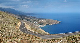
Sfakia landscape around Hóra Sfakíon
|
|
| Coordinates: 35°12′N 24°08′E / 35.200°N 24.133°ECoordinates: 35°12′N 24°08′E / 35.200°N 24.133°E | |
| Country | Greece |
| Administrative region | Crete |
| Regional unit | Chania |
| Government | |
| • Mayor | Giannis Zervos |
| Area | |
| • Municipality | 467.6 km2 (180.5 sq mi) |
| Population (2011) | |
| • Municipality | 1,889 |
| • Municipality density | 4.0/km2 (10/sq mi) |
| Time zone | EET (UTC+2) |
| • Summer (DST) | EEST (UTC+3) |
| Area code(s) | 73011 |
| Vehicle registration | ΧΝ |
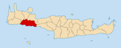
Sfakiá (Greek: Σφακιά) is a mountainous area in the southwestern part of the island of Crete, in the Chania regional unit. It is considered to be one of the few places in Greece that have never been fully occupied by foreign powers. With a 2011 census population of 1,889 inhabitants living on a land area of 467.589 km2 (180.537 sq mi), Sfakia is one of the largest and least densely populated municipalities on the island of Crete. The etymology of its name is disputed. According to the prevailing theory, it relates to its rugged terrain, deriving from the ancient Greek word σφαξ, meaning land chasm or gorge.
The road from Chania to Sfakiá crosses the island from north to south, through the village of Vryses. From this village the route crosses the White Mountains (Lefká Óri) to Hóra Sfakíon (35°12′N 24°08′E / 35.200°N 24.133°E) by the Libyan Sea. Halfway from Vrisses to Hóra Sfakíon is the fertile plateau of Askifou, surrounded by high mountain peaks. From here to Hóra Sfakíon the road is particularly spectacular. The road hugs the western slope of the Imbros Gorge offering scenic views. Another scenic route is that leading from Kapsodasos to the plateau of Kallikratis, northeast of Hóra Sfakíon.
...
Wikipedia


