Setauket
| Setauket-East Setauket, New York | |
|---|---|
| Census-designated place | |

The Setauket Presbyterian Church and Burial Ground, with the graveyard dating to the 1660s and the structure to 1812
|
|
 |
|
| Coordinates: 40°55′48″N 73°6′7″W / 40.93000°N 73.10194°WCoordinates: 40°55′48″N 73°6′7″W / 40.93000°N 73.10194°W | |
| Country | United States |
| State | New York |
| County | Suffolk |
| Area | |
| • Total | 9.3 sq mi (24.2 km2) |
| • Land | 8.5 sq mi (22.1 km2) |
| • Water | 0.8 sq mi (2.1 km2) |
| Population (2010) | |
| • Total | 15,477 |
| • Density | 1,700/sq mi (640/km2) |
| Time zone | Eastern (EST) (UTC-5) |
| • Summer (DST) | EDT (UTC-4) |
| FIPS code | 36-66481 |
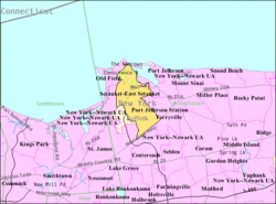
Setauket-East Setauket /səˈtɔːkɪt/, more commonly known as the Setaukets (or that region's core), is a census-designated place (CDP) in Suffolk County, New York, on the North Shore of Long Island. As of the 2010 United States Census, the CDP population was 15,477. The CDP encompasses the hamlets of Setauket (formerly West Setauket) and East Setauket. It was founded in 1655, the first settlement and namesake (after Anglicization) of the Town of Brookhaven.
Setauket was founded as an agricultural community in the mid-17th century, and was a regional center of activity during the American Revolutionary War noted for the Culper spy ring and the Battle of Setauket. Many of Setauket's early structures are intact and now form the Old Setauket Historic District. The Setaukets remain a mostly residential area, while bordering the more commercial enclaves of Port Jefferson and Stony Brook. The handful of businesses within the community largely cater to the over 24,500 students of Stony Brook University, which is adjacent to the CDP.
The name Setauket is derived from the historic Algonquian-speaking Setalcott Indians, who had lived in the area prior to its colonial period.
...
Wikipedia

