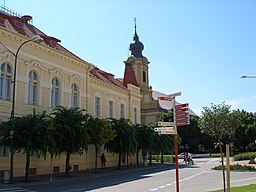
Sereď
| Sereď | ||
| Town | ||
|
View of Sered
|
||
|
||
| Country | Slovakia | |
|---|---|---|
| Region | Trnava | |
| District | Galanta | |
| Tourism region | Dolné Považie | |
| River | Váh | |
| Elevation | 128 m (420 ft) | |
| Coordinates | 48°17′N 17°44′E / 48.283°N 17.733°ECoordinates: 48°17′N 17°44′E / 48.283°N 17.733°E | |
| Area | 30.454 km2 (11.76 sq mi) | |
| Population | 17,224 (1 January 2010) | |
| Density | 566/km2 (1,466/sq mi) | |
| First mentioned | 1313 | |
| Mayor | Ing. Martin Tomčányi (SDKÚ-DS, SMER) | |
| Timezone | CET (UTC+1) | |
| - summer (DST) | CEST (UTC+2) | |
| Postal code | 926 01 | |
| Area code | +421-31 | |
| Car plate | GA | |
| Statistics: Statistical Office of the Slovak Republic | ||
| Website: www.sered.sk | ||
Sereď (Slovak pronunciation: [ˈserec]; Hungarian: Szered [ˈsɛrɛd]) is a town in southern Slovak Republic near Trnava, on the right bank of the Váh River on the Danubian Lowland. It has аpproximately 17,000 inhabitants.
Sereď lies at an altitude of 129 metres (423 ft) above sea level and covers an area of 30.454 square kilometres (11.8 sq mi). It is located in the Danubian Lowland on the Váh river, around 20 kilometres (12 mi) south-east of Trnava, 33 kilometres (21 mi) west of Nitra and around 55 kilometres (34 mi) east from Bratislava. The closest mountain ranges are the Little Carpathians to the west and Považský Inovec to the north.
The town was first mentioned in 1313 as Zereth. In the Middle Ages, it lay on the trade route called "Bohemian Road" which ran from Buda to Prague on the right bank of the Váh river. Thanks to its location, livestock and grain markets were held in the town and thousands of cattle moved through the town each year. Its commercial importance ended in 1846, when the Pozsony-Nagyszombat (now: Bratislava-Trnava) railway was built. However, the Seredian market tradition survived and the Seredian Market and Bier festival is held every year on St. John Baptist's Day (24 June). Sered had also been a large raft port and an important waterway until 1943 when a dam was built on the river Váh at Nosice. Since rafts carried not only wood but also salt from Poland, a major salt warehouse was built and the salt authority operated here. Its good location also attracted industrial investment. In 1845, a sugar refinery, later coffee processing and baking plant was opened.
...
Wikipedia


