
Sembawang
| Sembawang | |||||||
|---|---|---|---|---|---|---|---|
| Planning Area and HDB Town | |||||||
| Other transcription(s) | |||||||
| • Chinese | 三巴旺 胜宝旺 |
||||||
| • Pinyin | Sān Bā Wàng Shèng Băo Wàng |
||||||
| • Malay | Sembawang | ||||||
| • Tamil | செம்பவாங் | ||||||
From top left to right: HDB flats along Sungei Sembawang, Senoko Power Station, Sembawang Shipyard, MRT viaduct in Sembawang, Wak Hassan Beach
|
|||||||

Sembawang
|
|||||||
| Coordinates: 1°26′56.8″N 103°49′6.58″E / 1.449111°N 103.8184944°E | |||||||
| Country |
|
||||||
| Region |
|
||||||
| CDC | |||||||
| Town council |
|
||||||
| Constituency | |||||||
| Government | |||||||
| • Mayor |
North West CDC |
||||||
| • Members of Parliament |
Sembawang GRC
|
||||||
| Area | |||||||
| • Total | 12.34 km2 (4.76 sq mi) | ||||||
| • Residential | 3.31 km2 (1.28 sq mi) | ||||||
| Population (2015) | |||||||
| • Total | 76,530 | ||||||
| • Density | 6,200/km2 (16,000/sq mi) | ||||||
| Demonym(s) |
Official
Colloquial
|
||||||
| Dwelling units | 20,311 | ||||||
| Projected ultimate | 65,000 | ||||||


.jpg)


| Sembawang Naval Pier | |
|
|
North West CDC
Sembawang GRC
Official
Colloquial
Sembawang (Chinese: 三巴旺, Tamil: செம்பவாங்) is a planning area and residential town located at the northernmost tip of the North Region of Singapore. The relative location of Sembawang makes it Singapore's closest point to Peninsular Malaysia.
Sembawang planning area is bordered by Simpang to the east, Mandai to the south, Yishun to the southeast, Woodlands to the west and the Straits of Johor to the north.
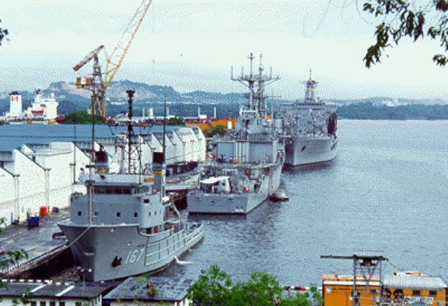
Despite the relatively large development in the Sembawang New Town, the area remains largely suburban, with military, industrial and recreational facilities at its periphery. It hosted a major naval base and port facilities since the early 20th century, and continues to handle regular shipping traffic today along its wharves.
The earliest reference to Sembawang is found in Franklin and Jackson's 1830 Map of Singapore, which refers to the River Tambuwang. The place is said to have got its name from the Sembawang tree, (Kayae ferruginea), which has been renamed Mesua ferruginea from 1980. This tree can be seen at Carpark C1, Sembawang Park.
The Sembawang area in the early twentieth century was the site of the Nee Soon Rubber estate. During the colonial times, Sembawang was home to a major British naval base, its construction of which began in 1928 and was completed in 1938. The base included dockyards, wharves and workshops, as well as supporting administrative, residential and commercial areas. The Naval Base has since been handed over to the Singapore government, which in 1968 converted it into a commercial dockyard (as Sembawang Shipyard, now part of Singapore Exchange-listed SembCorp Marine) that went on to become SembCorp, a major state-owned industrial conglomerate.
...
Wikipedia