Scipio, New York
| Scipio, New York | |
|---|---|
| Town | |

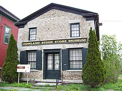
Howland Cobblestone Store, Sherwood, NY
|
|
 Location within Cayuga County and New York |
|
| Location within the state of New York | |
| Coordinates: 42°48′12″N 76°34′17″W / 42.80333°N 76.57139°WCoordinates: 42°48′12″N 76°34′17″W / 42.80333°N 76.57139°W | |
| Country | United States |
| State | New York |
| County | Cayuga |
| Government | |
| • Type | Town Council |
| • Town Supervisor | Keith M. Batman (D) |
| • Town Council |
Members' List
|
| Area | |
| • Total | 39.3 sq mi (101.8 km2) |
| • Land | 36.6 sq mi (94.7 km2) |
| • Water | 2.7 sq mi (7.1 km2) |
| Elevation | 1,214 ft (370 m) |
| Population (2010) | |
| • Total | 1,713 |
| • Density | 46.9/sq mi (18.1/km2) |
| Time zone | Eastern (EST) (UTC-5) |
| • Summer (DST) | EDT (UTC-4) |
| ZIP code | 13147 |
| Area code(s) | 315 |
| FIPS code | 36-65816 |
| GNIS feature ID | 0979476 |
| Website | www |
Scipio is a town in Cayuga County, New York, United States. The population was 1,713 at the 2010 census. The town name was provided by a clerk with an interest in the classics. Scipio is centrally located in the southern half of the county, south of Auburn.
Scipio was part of the Central New York Military Tract, which was land reserved for veterans of the Revolutionary War. The first settler arrived around 1790, and the town was formed in 1798 when Cayuga County was formed. The town was named after the Roman general Scipio Africanus. In 1823, part of Scipio was used to form the towns of Springport and Venice.
According to the United States Census Bureau, the town has a total area of 39.3 square miles (101.8 km2), of which 36.6 square miles (94.7 km2) is land and 2.7 square miles (7.1 km2), or 7.00%, is water.
The east town line is marked by Owasco Lake, one of the Finger Lakes.
New York State Route 34, New York State Route 34B, and New York State Route 38 are north-south highways in Scipio.
As of the census of 2000, there were 1,537 people, 571 households, and 424 families residing in the town. The population density was 41.9 people per square mile (16.2/km²). There were 702 housing units at an average density of 19.1 per square mile (7.4/km²). The racial makeup of the town was 97.59% White, 0.20% African American, 0.85% Native American, 0.59% Asian, 0.20% from other races, and 0.59% from two or more races. Hispanic or Latino of any race were 1.30% of the population.
...
Wikipedia

