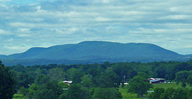
Schunemunk Mountain
| Schunemunk Mountain | |
|---|---|

Schunemunk Mountain from across the Hudson River
|
|
| Highest point | |
| Elevation | 1,664 ft (507 m) |
| Coordinates | 41°23′30″N 74°06′59″W / 41.3917605°N 74.1162557°WCoordinates: 41°23′30″N 74°06′59″W / 41.3917605°N 74.1162557°W |
| Geography | |
| Location | Orange County, New York, U.S. |
| Topo map | USGS Cornwall-on-Hudson |
| Climbing | |
| Easiest route | Hiking trail |
Schunemunk Mountain (also spelled Schunnemunk) is the highest mountain in Orange County, New York. The 1,664-foot (507 m) summit is located in the town of Blooming Grove, with other portions in Cornwall and Woodbury. The community of Mountain Lodge Park is built up its western slope.
The mountain is a popular recreational resource in the area. While only the northeastern quadrant and summit are part of the recently created Schunnemunk State Park, some popular hiking trails and access routes have long crossed the privately owned lands elsewhere on the mountain. Conservationists hope that eventually the state will be able to acquire the whole mountain.
Schunemunk is a long ridge running approximately northeast-southwest between Smith's Clove and Salisbury Mills. Along the more northerly of its length, the mountain has a double crest, with Barton Swamp lying between the two ridges. The summit lies on the more southeasterly ridge. Barton Swamp is drained by Perry Creek on the south and Baby Brook on the north. Much of the eastern side of the mountain is drained by Dark Hollow Brook. These are part of the Moodna Creek watershed, which encompasses all but the southeastern tip of the mountain. Moodna Creek drains into the Hudson River. The southeastern part of the mountain drains into the watershed of the Ramapo River.
About midway along its length, on the southeastern side of the mountain, is a spur known as High Knob or High Point, which overlooks Woodbury, New York. To the northwest, across a clove, lies Woodcock Mountain or Woodcock Hill, which reaches 1,030 feet (310 m).
The New York State Thruway runs alongside Schunemunk's eastern side for the length of the mountain just north of its Harriman exit. In addition to Mountain Lodge Park, two other hamlets in the area are closely associated with the mountain: Mountainville to the northeast and Central Valley to the southeast.
...
Wikipedia
