Moodna Creek
| Moodna Creek | |
| River | |
|
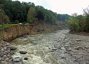
Moodna Creek from Forge Hill Rd. Bridge in New Windsor, showing widening of channel resulting from floods after Hurricane Irene
|
|
| Country | United States |
|---|---|
| State | New York |
| County | Orange |
| Towns | Cornwall, New Windsor, Blooming Grove |
| Tributaries | |
| - right | Woodbury Creek |
| Villages | Washingtonville |
| Source | Otter Kill |
| - location | Goshen Reservoir No. 2, Town of Goshen |
| - elevation | 460 ft (140 m) |
| - coordinates | 41°22′06″N 74°19′02″W / 41.36833°N 74.31722°W |
| Secondary source | Cromline Creek |
| - location | Tomahawk Lake, Blooming Grove |
| - elevation | 340 ft (104 m) |
| - coordinates | 41°24′57″N 74°13′07″W / 41.41583°N 74.21861°W |
| Source confluence | |
| - location | Blooming Grove, New York |
| - elevation | 300 ft (91 m) |
| - coordinates | 41°25′51″N 74°11′41″W / 41.43083°N 74.19472°W |
| Mouth | Hudson River |
| - location | Cornwall |
| - elevation | 0 ft (0 m) |
| - coordinates | 41°27′13″N 74°01′00″W / 41.45361°N 74.01667°WCoordinates: 41°27′13″N 74°01′00″W / 41.45361°N 74.01667°W |
| Length | 15.5 mi (25 km) |
| Basin | 187.2 sq mi (485 km2) |
|
Moodna Creek and its watershed and major tributaries
|
|
Moodna Creek is a small tributary of the Hudson River that drains eastern Orange County, New York. At 15.5 miles (25 km) in length from its source at the confluence of Cromline Creek and Otter Kill west of Washingtonville, it is the longest stream located entirely within the county.
Despite its small size relative to the Hudson, it has been a major influence on the topography of eastern central Orange County. Its 187.2-square-mile (485 km2) watershed, including not only both its parent streams but Woodbury Creek as well, reaches as far inland as Warwick as well as 21 other area communities. Near Salisbury Mills it is crossed by the Moodna Viaduct, the longest actively used railroad trestle east of the Mississippi.
"Moodna" is a corruption of the Dutch "Moordenaars", from Murderers' Creek, its original name. Local lore has it that the name came from the massacre of the Stacys, an early family of settlers, along its banks. Murderers' Creek was in common use in the mid-18th century, however by the dawn of the 20th Moodna was being used on maps although the older name persisted.
From the confluence, just off NY 208, the Moodna flows through woods and field alongside the highway for a short distance, then veers southwestward to where it crosses NY 94. The creek and Route 94 will keep close company for several miles as it turns eastward again into Washingtonville, where it crosses under 208 just south of downtown. Past the village, Route 94 and the creek enter first the Town of Blooming Grove and then Cornwall. They run close together at first, then further apart as the Moodna valley opens up just to the north of Schunemunk Mountain. At Salisbury Mills the viaduct crosses 193 feet (59 m) overhead.
...
Wikipedia


