
Schramberg
| Schramberg | ||
|---|---|---|
|
||

Schramberg
|
||
|
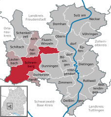
Location of Schramberg within Rottweil district
  |
||
| Coordinates: 48°13′37″N 08°23′03″E / 48.22694°N 8.38417°ECoordinates: 48°13′37″N 08°23′03″E / 48.22694°N 8.38417°E | ||
| Country | Germany | |
| State | Baden-Württemberg | |
| Admin. region | Freiburg | |
| District | Rottweil | |
| Government | ||
| • Lord Mayor | Thomas Herzog | |
| Area | ||
| • Total | 80.70 km2 (31.16 sq mi) | |
| Population (2015-12-31) | ||
| • Total | 20,985 | |
| • Density | 260/km2 (670/sq mi) | |
| Time zone | CET/CEST (UTC+1/+2) | |
| Postal codes | 78142-44, 78701–13 | |
| Dialling codes | 07422 | |
| Vehicle registration | RW | |
| Website | schramberg.de | |

Schramberg is a town in the district of Rottweil, in Baden-Württemberg, Germany. It is situated in the eastern Black Forest, 25 km northwest of Rottweil. With all of its districts (Talstadt, Sulgen, Waldmössingen, Heiligenbronn, Schönbronn and Tennenbronn (since 2006)), it has about 22,000 inhabitants.
One of the streams flowing through the Schramberg valley is the Schiltach. The "Bach na Fahrt", a traditional raft race held on Carnival Monday, is known far and wide and attracts up to 30,000 spectators each year.
The following towns and municipalities border Schramberg:
Lauterbach, Schiltach, Aichhalden, Fluorn-Winzeln, Oberndorf am Neckar, Bösingen, Dunningen, Eschbronn, Hardt, Königsfeld im Schwarzwald, Sankt Georgen im Schwarzwald, Triberg im Schwarzwald (Schwarzwald-Baar-Kreis) and Hornberg (Ortenaukreis).
Schramberg was the terminus of the Schiltach-Schramberg railway, which was formerly an important railway line for freight traffic. The line existed from 1892–1990.
The origins of Schramberg date back to the year 1293, when the locality was first described as "Schrammenberg" ("wounded" or "scarfed hill"). From 1643 Schramberg was the centre of the Herrschaft Schramberg, belonging to Further Austria until 1805. From 1805 Schramberg was part of the Kingdom of Württemberg.
...
Wikipedia