Santa Ana, CA
| Santa Ana, California | |||||||
|---|---|---|---|---|---|---|---|
| City | |||||||
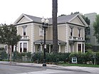
Clockwise from top: Old Orange County Courthouse, Bowers Museum, Discovery Cube Orange County, Minter House, Santa Ana Regional Transportation Center
|
|||||||
|
|||||||
| Motto: Education First | |||||||
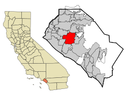
 Location of Santa Ana within Orange County, California |
|||||||
| Location in the United States | |||||||
| Coordinates: 33°44′27″N 117°52′53″W / 33.74083°N 117.88139°WCoordinates: 33°44′27″N 117°52′53″W / 33.74083°N 117.88139°W | |||||||
| Country | United States | ||||||
| State | California | ||||||
| County | Orange | ||||||
| Founded | 1869 | ||||||
| Incorporated | June 1, 1886 | ||||||
| Government | |||||||
| • Mayor | Miguel A. Pulido | ||||||
| Area | |||||||
| • Total | 27.518 sq mi (71.271 km2) | ||||||
| • Land | 27.270 sq mi (70.628 km2) | ||||||
| • Water | 0.248 sq mi (0.643 km2) 0.90% | ||||||
| Elevation | 115 ft (35 m) | ||||||
| Population (2010) | |||||||
| • Total | 324,528 | ||||||
| • Estimate (2014) | 334,909 | ||||||
| • Rank |
2nd in Orange County 11th in California 57th in the United States |
||||||
| • Density | 12,000/sq mi (4,600/km2) | ||||||
| Time zone | Pacific (UTC-8) | ||||||
| • Summer (DST) | PDT (UTC-7) | ||||||
| ZIP codes | 92701–92708, 92711, 92712, 92728, 92735, 92799 | ||||||
| Area code | 657/714, 949 | ||||||
| FIPS code | 06-69000 | ||||||
| GNIS feature IDs | 1652790,2411814 | ||||||
| Website | santa-ana |
||||||
Santa Ana /ˌsæntə ˈænə/ (Spanish for "Saint Anne") is the county seat and second most populous city in Orange County, California. The United States Census Bureau estimated its 2011 population at 329,427, making Santa Ana the 57th most-populous city in the United States.
Santa Ana is located in Southern California, adjacent to the Santa Ana River, about 10 miles (16 km) away from the California coast. Founded in 1869, the city is part of the Greater Los Angeles Area, the second largest metropolitan area in the United States with almost 18 million residents in 2010. Santa Ana is a very densely populated city, ranking fourth nationally in that regard among cities of over 300,000 residents (trailing only New York City, San Francisco, and Boston). In 2011 Forbes ranked Santa Ana the fourth-safest city of over 250,000 residents in the United States.
Santa Ana lends its name to the Santa Ana Freeway (I-5), which runs through the city. It also shares its name with the nearby Santa Ana Mountains, and the Santa Ana winds, which have historically fueled seasonal wildfires throughout Southern California. The current Office of Management and Budget (OMB) metropolitan designation for the Orange County Area is Santa Ana–Anaheim–Irvine, California.
...
Wikipedia


