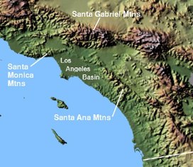
Santa Ana Mountains
| Santa Ana Mountains | |
|---|---|

(2008)
|
|
| Highest point | |
| Peak | Santiago Peak |
| Elevation | 5,689 ft (1,734 m) |
| Coordinates | 33°42′38″N 117°32′03″W / 33.71056°N 117.53417°WCoordinates: 33°42′38″N 117°32′03″W / 33.71056°N 117.53417°W |
| Dimensions | |
| Length | 61 mi (98 km) |
| Area | 2,104 sq mi (5,450 km2) |
| Geography | |
| Country | United States |
| State | California |
| Counties | Orange, Riverside and San Diego |
| Geology | |
| Age of rock | Triassic-Jurassic |
| Type of rock | metasedimentary |
The Santa Ana Mountains are a short peninsular mountain range along the coast of Southern California in the United States. They extend for approximately 61 miles (98 km) southeast of the Los Angeles Basin largely along the border between Orange and Riverside counties.
The range starts in the north at the Whittier Fault and Santa Ana Canyon, through which the Santa Ana River flows. To the north of the canyon are the smaller Chino Hills in Los Angeles County. The northernmost summit of the Santa Anas, at 3,045 feet (928 m), is Sierra Peak. From there, the major summits are Pleasants Peak, 4,007 feet (1,221 m); Bedford Peak, 3,800 feet (1,200 m); and Bald Peak, 3,947 feet (1,203 m). The next two peaks, Modjeska, 5,496 feet (1,675 m); and Santiago, 5,689 feet (1,734 m), the highest summit in the range; form Saddleback Ridge. Saddleback, located approximately 20 mi (32 km) east of Santa Ana, is visible from much of Southern California.
South of Saddleback are Trabuco Peak, 4,613 feet (1,406 m); Los Pinos Peak, 4,510 feet (1,370 m) and Sitton Peak, 3,273 feet (998 m). Elsinore Peak, 3,575 feet (1,090 m) is included in a subrange called the Elsinore Mountains, which are west of Lake Elsinore. San Mateo Peak 3,591 feet (1,095 m) marks the highpoint of this range. Margarita Peak, 3,189 feet (972 m); and Redonda Mesa, 2,825 feet (861 m) are part of the Santa Margarita Mountains, a subrange of the Santa Anas that extends down to Camp Pendleton and Fallbrook. Southeast of the Elsinore Mountains is the Santa Rosa Plateau, named for the Rancho Santa Rosa that once encompassed it. At the south end of the plateau there is a steep escarpment from the basalt capped mesas that line it, that descends from about 500 feet at Mesa de Burro to Sandia Creek on the east to about 1800 feet at Avenaloca Mesa to De Luz Creek in the west. From the foot of the escarpment, the mountains and canyons of De Luz, Sandia Creek and others below it, run to the south to the Santa Margarita River. The range ends roughly at the Santa Margarita River.
...
Wikipedia

