Sant'Antioco
|
Sant'Antioco Santu Antiogu |
||
|---|---|---|
| Comune | ||
| Comune di Sant'Antioco | ||

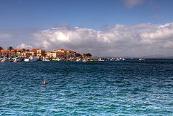
Seafront
|
||
|
||
| Location of Sant'Antioco in Sardinia | ||
| Coordinates: 39°04′N 08°27′E / 39.067°N 8.450°ECoordinates: 39°04′N 08°27′E / 39.067°N 8.450°E | ||
| Country | Italy | |
| Region | Sardinia | |
| Province / Metropolitan city | South Sardinia | |
| Frazioni | Maladroxia | |
| Government | ||
| • Mayor | Mario Corongiu (2012) (civic Party) | |
| Area | ||
| • Total | 115.59 km2 (44.63 sq mi) | |
| Elevation | 10 m (30 ft) | |
| Population (2014) | ||
| • Total | 11,423 | |
| • Density | 99/km2 (260/sq mi) | |
| Demonym(s) | Antiochensi | |
| Time zone | CET (UTC+1) | |
| • Summer (DST) | CEST (UTC+2) | |
| Postal code | 09017 | |
| Dialing code | 0781 | |
| Patron saint | Saint Antiochus (Sant'Antioco) | |
| Website | Official website | |
Sant'Antioco (Italian pronunciation: [santanˈtiːoko]; Sardinian: Santu Antiogu) is the name of both an island and a municipality (comune) in southwestern Sardinia, in the Province of South Sardinia, in Sulcis zone. With a population of 11,730, the municipality of Sant'Antioco it is the island's largest community. It is also the site of ancient Sulci, considered the second city of Sardinia in antiquity.
Sant'Antioco is the second largest island of the Sardinian region, after Sardinia itself, with a surface of 109 square kilometres (42 sq mi); it is also the fourth largest in Italy after Sicily, Sardinia itself and Elba. It is located some 87 kilometres (54 mi) from Cagliari, to which is connected through the SS126 state road, using a modern bridge. The island is divided between the two municipalities of Sant'Antioco and Calasetta. Other settlements are the small tourist resort of Maladroxia (a frazione of Sant'Antioco municipality) and Cussorgia, part of Calasetta.
The island of Sant'Antioco was settled at least from the 5th millennium BC (the so-called culture of San Michele of Ozieri), which was based mainly on fishing and agriculture. Typical tombs (called domus de janas) and menhirs belonging to this culture have been found. The island also housed nuraghe civilizations: findings include the nuraghe of Su Niu de Su Crobu ("Crow's Nest").
In the 8th century BC the Phoenicians founded a new settlement, with the name of Solki, of which a tophet (children) necropolis has been excavated. Later (6th century BC) it became a Carthaginian colony, to which another necropolis belongs. The Punic domination ended in the 2nd century BC, when Solki was conquered by the Romans, who connected it to the mainland through an artificial isthmus. During the civil war between Julius Caesar and Pompey it sided with the latter, being severely punished after his defeat. During Roman times, it was called Plumbaria, after its lead deposits.
...
Wikipedia


