Sanok
| Sanok | |||
|---|---|---|---|

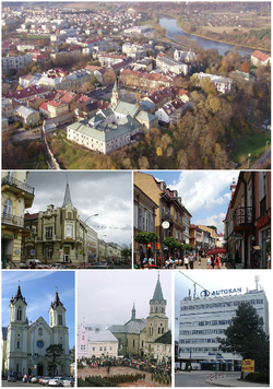
Town view, Top: Areal view of the San River and Wojtostwo town centre area, including the Old Market Square, and Franciscan Monastery. Middle left:Teseusza Kosciuszki Street, Middle right:Three Maja Street, Bottom left:Przemienienia Panskiego Cathedral, Bottom middle:Franciscan Cathedral, Bottom right: Autosan headquarters in Sanok.
|
|||
|
|||
| Motto: Libera Regia Civitas Free Royal City |
|||
| Coordinates: 49°33′N 22°13′E / 49.550°N 22.217°E | |||
| Country |
|
||
| Voivodeship |
|
||
| County | Sanok County | ||
| Gmina | Sanok (urban gmina) | ||
| Established | before 12th century | ||
| Town rights | 1339 | ||
| Government | |||
| • Mayor | Wojciech Blecharczyk | ||
| Area | |||
| • Total | 38.15 km2 (14.73 sq mi) | ||
| Population (2008) | |||
| • Total | 39,588 | ||
| • Density | 1,000/km2 (2,700/sq mi) | ||
| Time zone | CET (UTC+1) | ||
| • Summer (DST) | CEST (UTC+2) | ||
| Postal code | 38-500 | ||
| Area code(s) | +48 13 | ||
| Car plates | RSA | ||
| Website | http://www.sanok.pl | ||
Sanok [ˈsanɔk] (in full the Royal Free City of Sanok - Polish: Królewskie Wolne Miasto Sanok, Ukrainian: Cянік, Latin: Sanocum, Yiddish: סאניק, Sonik) is a town in south-eastern Poland with 39,110 inhabitants, as of 2 June 2009.
It is the capital of Sanok County in the Subcarpathian Voivodeship. Previously, it was in the Krosno Voivodeship (1975–1998) and in the Ruthenian Voivodeship (1340–1772), which was part of the Lesser Poland province. Historically it was part of the Land of Sanok and the Ruthenian Voivodeship. This historic city is situated on the San River at the foot of Castle Hill in the Lesser Poland (Małopolska) region. It lies in a wooded, hilly area near the national road number 28, which runs along southern Poland, from Ustrzyki Dolne to Wadowice (340 km or 211 mi away). It is located in the heartland of the Pogórze Bukowskie part of Doły (Pits), and its average elevation is 300 m (984 ft) above sea level, although there are some hills located within the confines of the city. Sanok is located on the bank of the river San. The area surrounding mountain range stretching between the Wisłok, Osława and San Rivers in the Salt Mountains (Central Beskidian Piedmont), in the inland with temperateness climate. The hills of the Bieszczady mountain range are typical for this countryside. Sanok County is bordered by Krosno County to the west, Brzozów County to the north, Przemyśl County to the north-east and Lesko County to the east. It also borders Slovakia to the south. Before World War II, the Oslawa and San Rivers line was designated the wild frontier between Poles and Lemkos. The city is a member of Carpathian Euroregion, which is designed to bring together the people who inhabit the region of the Carpathian Mountains and to facilitate their cooperation in the fields of science, culture, education, trade, tourism and economy.
...
Wikipedia


