Pogórze Bukowskie
| Bukowskie Upland | |
|---|---|
| Polish: Pogórze Bukowskie | |

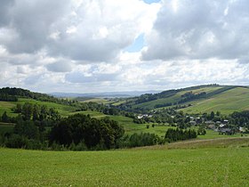
A view from Bukowica Peak in western Nowotaniec.
|
|
| Highest point | |
| Peak | Żurawinka |
| Elevation | 664 m (2,178 ft) |
| Coordinates | 49°27′00″N 22°46′44″E / 49.45000°N 22.77889°E |
| Dimensions | |
| Length | 45 km (28 mi) west-east |
| Width | 15–20 km (9–12 mi), north-south |
| Area | 720 km2 (280 sq mi) |
| Geography | |
| Country | Poland |
| Range coordinates | 49°29′N 22°40′E / 49.483°N 22.667°ECoordinates: 49°29′N 22°40′E / 49.483°N 22.667°E |
| Parent range |
Doły Jasielsko Sanockie in Gmina Bukowsko, Gmina Besko, Gmina Sanok, Gmina Lesko, Gmina Komańcza |
| Borders on |
Bieszczady Mountains, and Low Beskids |
| Geology | |
| Type of rock | granite, gneiss, limestone |
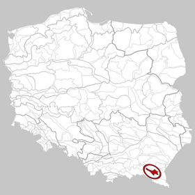
The Pogórze Bukowskie (also Bukowskie Upland, Bukowsko Upland, Bukowskie Piedmont, Bukowskie Plateau, Bukowskie Foothills) is one of the Beskids mountain ranges of the Outer Eastern Carpathians in southeastern Poland, part of the Central Beskidian Piedmont. Is a hilly region in Poland (Sanok County, and Podkarpacie), between Beskid Niski and Bieszczady near the river Osława and San. Its name comes from the west Slavic dialect word buk, meaning "beech".
Important villages in the region include Bukowsko, Komańcza, Nowotaniec, Zagórz, Wola Sękowa, Wola Piotrowa, and Lesko. It is home to the Uniwersytet Ludowy, opened in 2005, which contains many artworks and effects of the folk handworks inspiration. Pogórze Bukowskie is situated in the poorest region of Poland.
The region was a site of contention between Poland, Kievan Rus and Hungary starting as far back as the 9th century.
Until 1947, 45% of the population of this part of the mountains were Lemkos and Dolinians (both subgroups of Rusyns), 45% Polish Uplanders and 10% Jews. The killing of the Polish General Karol Świerczewski in Jabłonki by the Ukrainian Insurgent Army in 1947 was the direct cause of the replacement of the Lemkos, the so-called Operation Vistula.
...
Wikipedia

